How to Plan an Amazing Seattle to San Francisco Road Trip
If you’ve spent any time at all in our little corner of the internet, you know that we’re big fans of both the Pacific Northwest AND Northern California, the two places we’ve called home together.
The road trip we’re about to talk about – the drive between Seattle and San Francisco – takes you through some of our absolute favorite places on earth, and showcases much of the natural beauty that makes the west coast of the USA incredibly special.
We basically spent a full two months on this route a few summers ago, after we quit our corporate jobs to “travel the world” (in February of 2020…whoops) and lived in a converted Honda Odyssey for the better part of two years, and it was every bit as memorable, beautiful, and amazing as you might imagine.
Since then, we regularly drive it because our families are located in San Francisco and Seattle, respectively. And we live in Portland, Oregon now, so many of the stops on this itinerary are basically in our backyard.
There are a nearly unlimited number of route combinations you could take to get from San Francisco to Seattle, but which is the best?
Well, that depends on a bunch of different factors, like what time of year it is, how much time you have, whether or not you’re looking to do some hiking, if you’re a beach or mountain person, and too many others to list.
In this guide to planning your Seattle to San Francisco road trip, we’ll give you the best stops to make along the drive from San Francisco to Seattle, and do our best to present you with itinerary options for the various factors we mentioned above (namely time of year and amount of time you have, in this case).
We’ve driven the coastal route, the central route, and the “drive-it-all-in-one-shot” route (which we definitely don’t recommend at all).
The point is that we have plenty of personal experience to draw from, and we’re going to use that experience to help you plan an amazing trip yourself.
Sound good to you? Let’s get into it.
Disclaimer: Some of the links in this post, like hotel links, are affiliate links, meaning at no additional cost to you, we make a little bit of money if you click through and book. That being said, we would never recommend something to you that we don’t stand behind 100%.
How Much Time Do You Need for This Road Trip?
You can totally make it between Seattle and San Francisco in one day. However, it’ll take 13 hours, and it’s going to be miserable because it’s a long, mostly boring drive straight down I-5.
Trust me, I’ve done it (Matt here!).
Twice.
In the past few years.
The I-5 corridor is the quickest and most direct way to get from Seattle to San Francisco, but it is absolutely not the route you should take if you’re looking to experience the gorgeous scenery of the Pacific Northwest and Northern California.
Instead, the route we’re recommending (more on this below) is almost 1,200 miles and includes 24 hours of driving, which means you’re going to want a fair bit of time to explore along the way.
We would say that the ideal amount of time for this trip would be 14 days (or more) with 10 days being the minimum amount of time we’d recommend without having to make too many cuts.
If you have less time (like 7-10 days), we’d go ahead and stick to the coastal route and go into it knowing that you’re going to have some long days of driving.
An important note here: we’re NOT including Seattle or San Francisco in the number of days in the road trip. If you want more information on those places, like how much time to spend, where to stay, and what to do, here are our Seattle travel guides, and here are our San Francisco travel guides.
Where to Fly in and Out of
Usually, this section is “where to start and end your road trip” but, given that this guide is about driving between two specific cities, I feel like that’s pretty self explanatory here.
Instead, let’s talk about what airports to fly in and out of if you’re planning on flying to the west coast.
Seattle is an easy one. There’s only really one major airport in the Seattle area, Seattle-Tacoma International Airport (SEA).
It’s about 30 minutes south of the core of Seattle (meaning you’ll skip the bulk of traffic if you pick up a car here and immediately head south), but it’s well-connected to the city.
There’s a second, much smaller airport – Paine Field (PAE) – just north of Seattle, but the convenience of flying out of a small airport (and time saved going through security) is offset by the fact that it has very, very few flights available.
Now let’s talk about flying out of San Francisco.
Flying in or out of San Francisco can be a bit of a nightmare thanks to weather delays caused by the infamous fog that flows in and out of the city in the morning and afternoon.
We lived in San Francisco for almost a decade, and experienced those delays firsthand.
You have two airport options in the San Francisco area.
First is San Francisco International Airport (SFO) which is the bigger airport with more direct flight options. It’s also the most convenient airport for access to San Francisco itself.
However, it’s also the airport that is most famous for delays.
The second airport option in the Bay Area is Oakland San Francisco Bay Airport (OAK), which is across the Bay Bridge in Oakland, California.
It’s a smaller airport with fewer flight options, it’s a little harder to get into San Francisco, but it isn’t subject to the fog, and therefore usually has fewer weather delays.
DO NOT FLY INTO SAN JOSE. It’s over an hour south of San Francisco, sometimes more with the ugly Silicon Valley traffic that clogs up the freeways there.
Which Route to Take Between Seattle and San Francisco
We’ve gone back and forth on this question over the years and iterations of this guide, and the challenge here is a good one to have; there are SO MANY great places to see between Seattle and San Francisco that it would take a month or more to fit them all into one itinerary.
However, we’ve already said that we think 14 days is the right amount of time here, so the next question is what to prioritize within that timeframe.
We’re going to do our best to optimize for the variety of landscapes you’ll encounter along the route.
Now, we think that the coastal route through California is the clear winner (we love the northern California coast between SF and the Oregon border), so we’re going to recommend the inland route through Washington and Oregon.
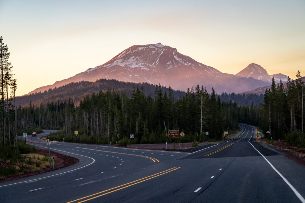
That route will take you down I-5 with a pitstop in Mount Rainier National Park, then on into the Columbia River Gorge, through the Cascades, and then down through Bend and Crater Lake National Park.
From there, you’re going to have a long day of driving to get out to the California coast, where you’ll hop on Highway 101 (then onto the famous Highway 1) to finish the drive down to San Francisco.
Here’s a rough map of what that ideal route looks like.
It’s worth noting that if you’re doing this drive earlier in the spring or in the winter, the coastal route is likely going to be your best bet all the way down.
In the mountains, roads close and trails are covered in snow into the early summer months, and you’ll have more available to see on the coast (albeit with a fair amount of rain).
3 Great Example Road Trip Itineraries
After going back and forth and trying to figure out a way that consolidates all of our thoughts into one singular “best” version of this road trip, we realized that there are just too many variables.
For example, if you’re not into (or able) to do a lot of hiking, it might not make sense to visit Mount Rainier National Park, which is all about the hiking (we think).
Another example, and this is the comment/email we get most often about this guide, would be if you’re planning this trip between November and May, when roads and trails will be closed on the mountainous route and it probably makes more sense to go the coastal route.
There are about 10 other variables that were brought up when we were trying to organize this guide that would affect which stops you make.
So, instead, here’s how this is going to work.
First, we’re going to give you three different versions that we think will be best for 90% of people thinking about doing this drive that will cover a variety of different interests.
We’ll give you our “best” version of this trip, which includes the route we talked about above through the mountains in Washington and Oregon and down the northern California coast, but we’ll also give you two alternate itineraries – one for the winter and spring version and one for people who aren’t into hiking.
The idea is that you can use these itineraries to organize your time on the road, and fill in the details at each stop with all the information in the main body of the guide below.
We’ve designed each road trip for 14 days, which is the ideal amount of time for this drive (we think).
Our Top Itinerary Recommendation
As we covered in the route section above, the ideal version of this road trip includes stretches through the mountains and along the coast because that gives you the widest breadth of different landscapes.
As we also covered above, the mountain stretch in Washington and Oregon encompasses several of our favorite places on earth, so we’d do the route through the Cascades through Washington and Oregon, and then hop over to the California coast and finish the drive into San Francisco.
This route gives you everything from alpine meadows and coastal vistas to charming small towns and towering redwoods.
Taking this route means starting down the I-5 corridor and making a detour to Paradise at Mount Rainier National Park before shooting out through the Columbia River Gorge and starting south through the Cascades.
At the southern end of Oregon after Crater Lake, you’d then head out to the coast (it will involve a bit of extra driving) and follow it through the giant redwoods, past a bunch of excellent beaches and small towns, and down into San Francisco.
This is one of the most beautiful drives in the world, and you should savor every second of it by taking the longer, more circuitous Highway 1.
Here’s what that route looks like written out.
- Day 1: Mount Rainier National Park
- Day 2: Mount Rainier National Park
- Day 3: Portland
- Day 4: Portland
- Day 5: Hood River
- Day 6: Bend
- Day 7: Bend
- Day 8: Crater Lake
- Day 9: Crater Lake
- Day 10: Trinidad (the Redwoods)
- Day 11: Trinidad (the Redwoods)
- Day 12: Mendocino
- Day 13: Mendocino
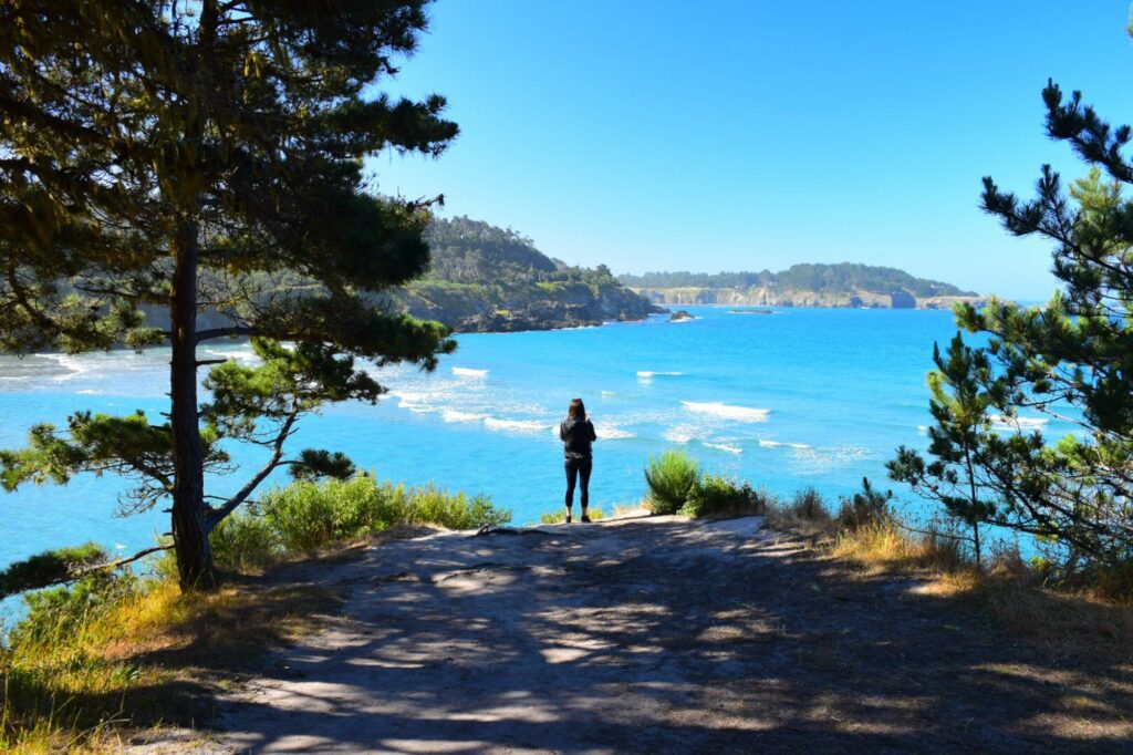
- Day 14: Point Reyes + Marin Headlands
If you have less time, we’d strongly recommend Mount Rainier being the first thing you cut.
We love Rainier (here’s our guide to our favorite hikes in Mount Rainier National Park), but it’s also a bit of a detour from your route.
A Road Trip for Non-Hikers
If you’re not a big hiker, then you can probably skip Mount Rainier because almost all of our favorite things to do in Mount Rainier National Park involve at least a little hiking.
You might be more interested in Olympic National Park, which has more accessible areas if you’re not into hiking – here’s our itinerary for Olympic National Park.
In this scenario, we’d essentially follow the coastal route, with a stop in Portland at the top to soak up the green spaces and food scene that we love about our adopted home city (here’s our guide to our favorite things to do in Portland).
From there, you’d shoot out to Astoria, where you’ll hop on Highway 101 and follow it for hundreds of miles south along the Oregon and California coasts.
Here’s what that itinerary might look like written out.
- Day 1: Portland
- Day 2: Portland (day trip to the Columbia River Gorge)
- Day 3: Astoria
- Day 4: Cannon Beach
- Day 5: Tillamook
- Day 6: Newport
- Day 7: Newport
- Day 8: Coos Bay
- Day 9: Trinidad
- Day 10: Trinidad
- Day 11: Mendocino
- Day 12: Mendocino
- Day 13: Point Reyes
- Day 14: Point Reyes
You’ll notice that, in the guide below, we only have the details for the stops featured on the “ideal” version of this trip.
However, fear not, we have other guides with plenty of detail to help you plan the Oregon Coast and Olympic National Park pieces of your trip.
Here’s our guide to planning an Oregon Coast road trip, and here are our guides to Olympic National Park (which includes our favorite things to do, an itinerary, and our favorite hikes).
The Coastal Route (A Winter & Spring Road Trip)
If you’re planning a road trip for the winter or spring (basically November through May), then the route through the mountains is going to present a couple of problems.
Namely the road closures in Mount Rainier National Park and Crater Lake National Park (and winter conditions in general) and snow on trails that make most of the destinations on the ideal route above inaccessible.
In the winter and spring, we’d strongly recommend taking the coastal route from top to bottom, starting in Olympic National Park – the coastal areas and the rainforests are accessible year round – and making your way south all the way past Point Reyes on the California coast just north of SF.
There’s a good chance that it’s going to be wet, grey, and potentially stormy, but that’s part of the charm of the coast we think.
We’ve done this road trip in February, and it was freezing on the northern coast, and stormy on the southern coast, but we still enjoyed it!
Here’s what that itinerary looks like written out.
- Day 1: Olympic National Park (Forks)
- Day 2: Olympic National Park (Forks)
- Day 3: Astoria
- Day 4: Cannon Beach
- Day 5: Tillamook
- Day 6: Newport
- Day 7: Newport
- Day 8: Coos Bay
- Day 9: Trinidad
- Day 10: Trinidad
- Day 11: Mendocino
- Day 12: Mendocino
- Day 13: Point Reyes
- Day 14: Point Reyes
Note that we’d focus mostly on the area around Forks when you’re in Olympic National Park, which includes some nice Pacific beaches and the coastal temperate rainforest.
The road to Hurricane Ridge will likely be closed (depending on your exact timing), though places like Lake Crescent and Sol Duc Falls will be accessible.
Our Favorite Stops to Make on Your Seattle to San Francisco Road Trip
Now, onto the main attraction. We’re going to give you our top stops to make on your drive that we like and think are worth your time.
We’ll give you the stops that are along the route we’ve mentioned in the main recommended itinerary above, along with all the details you need to make the most of your time in those places.
Some stops are bigger stops that deserve the better part of a day, some are smaller stops that might take a few hours. We’ll give you a recommendation, and leave it up to you to decide.
Along with the three itineraries we covered above, we think you can use the two pieces of this guide as tools in planning your own trip.
You can use the itineraries to organize your time at a high level, then the information in the section for each individual stop to fill in the details.
One big thing that we’d avoid is having too many one night stops.
Yes, if you’re trying to do this drive in five days, you’re going to need to stay in places for one night.
With more time, we’d encourage you to choose home bases where you stay for two nights to avoid moving around all the time and, most importantly, packing all of your stuff up every single day (which we can definitely say from experience, sucks).
For example, Mendocino is a great home base for exploring the coastal areas just north and south, but also for exploring the Anderson Valley, a highly underrated wine region just inland from Mendocino.
Rather than staying one night in each place, just stay two nights in Mendocino and make the scenic drive into the Anderson Valley for the day.
And now, with that out of the way, let’s get into the specific stops along the way!
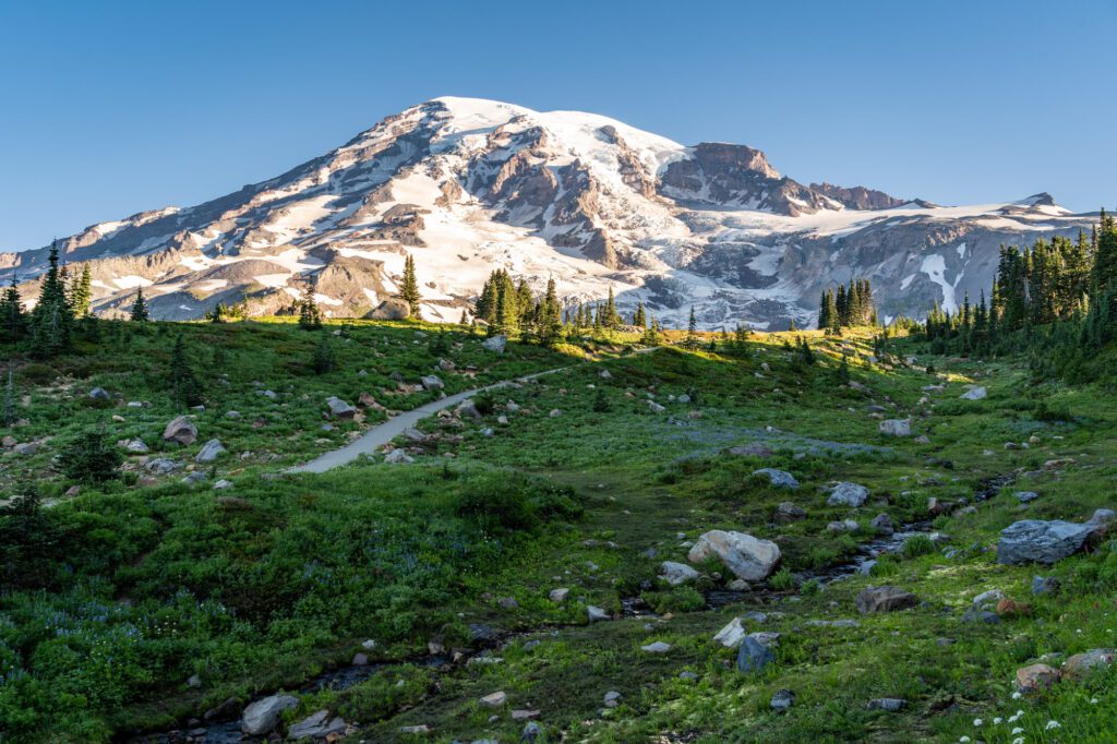
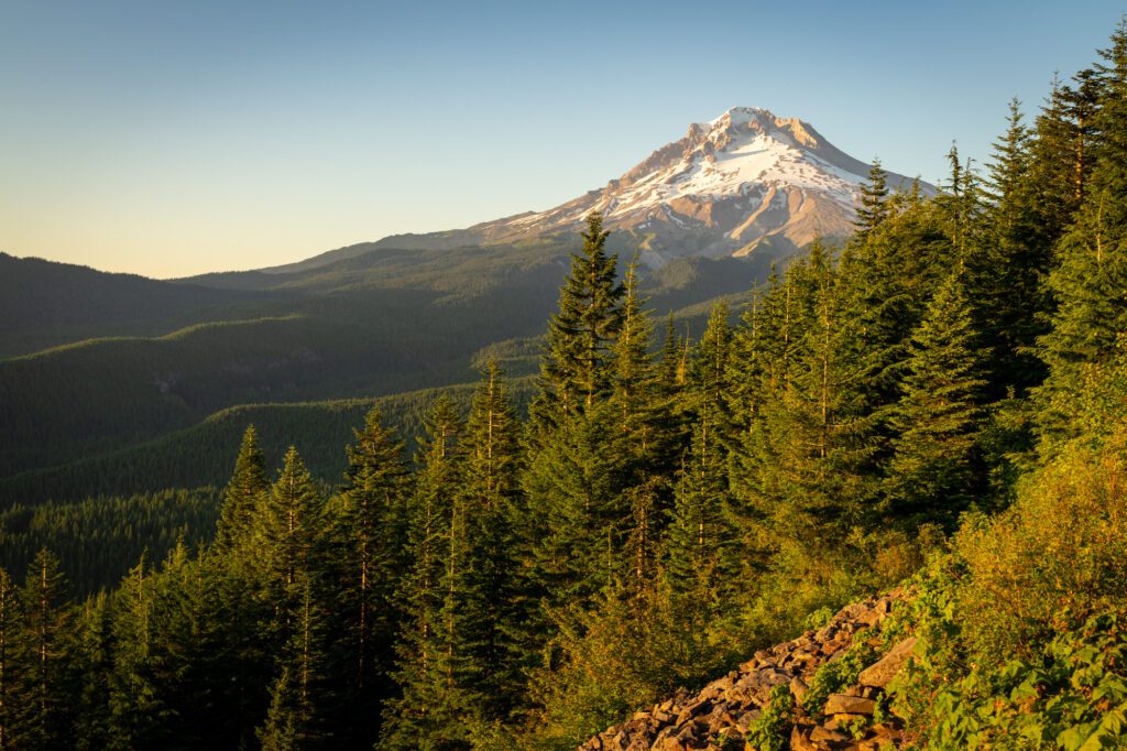
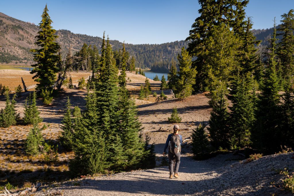
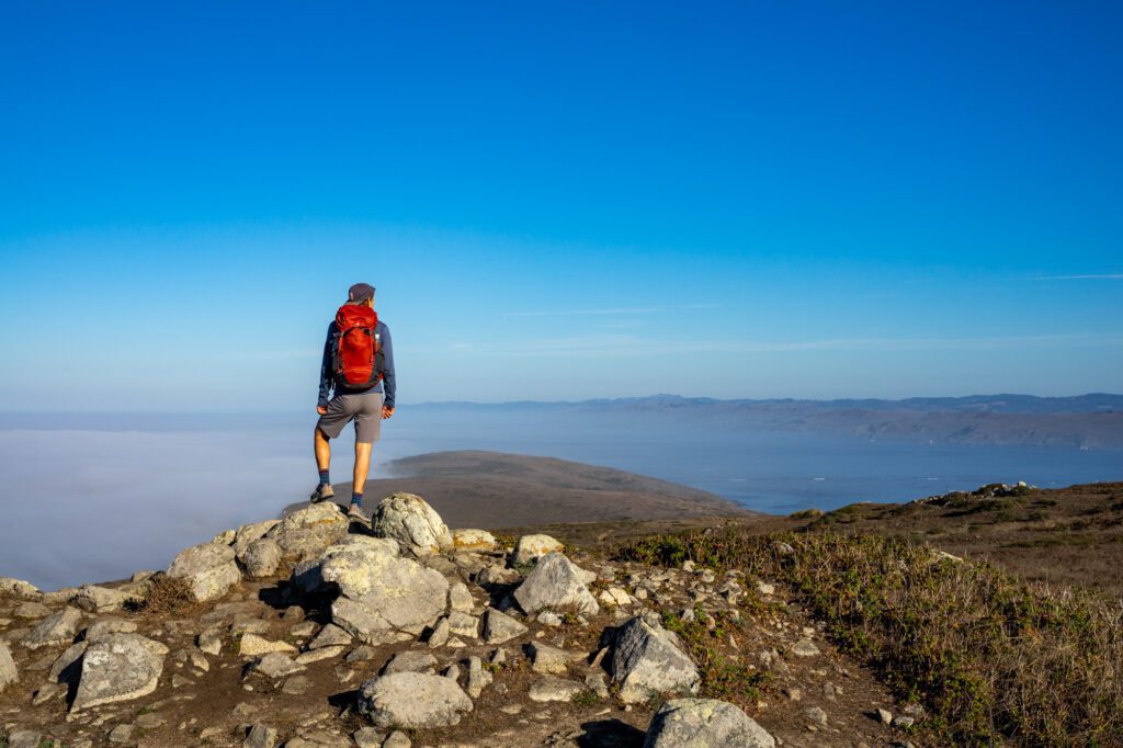
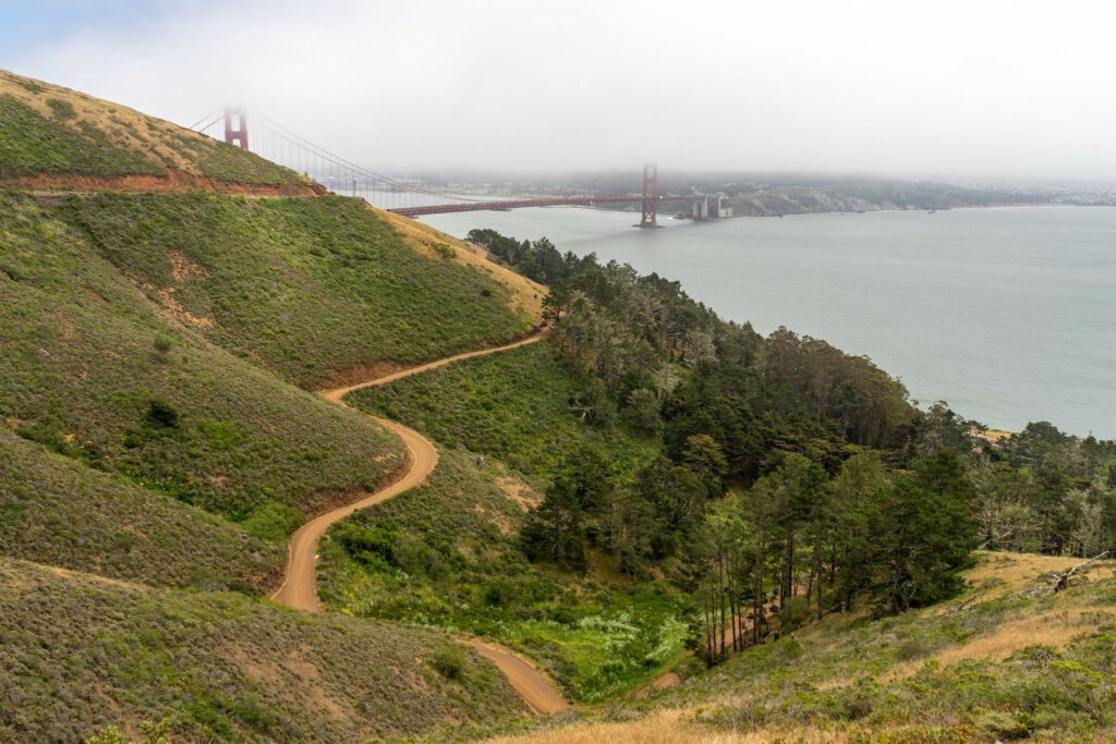
Mount Rainier National Park (Paradise)
Drive time from Seattle: 2 hours 30 minutes / 110 miles
Mount Rainier National Park is the crown jewel of the Pacific Northwest.
In most of Western Washington, the definition of a “good day” usually involves whether the Mountain is visible or not.
It is called Tahoma (or Tacoma) in the Salish language, but the name “Rainier” is so named after a friend of a British officer in the Royal Navy, which is pretty classic.
Mount Rainier, the tallest peak in the Cascades that range from Washington down through Oregon, is an awe-inspiring place to visit.
Everything from the abundance of wildflowers in the early summer to the lenticular cloud that swirls over the peak, building in strength throughout the day, is spectacular.
We can’t get enough of Mount Rainier National Park, and would encourage you to make an effort to visit on your drive (though it is worth noting that it’s a bit of a detour from your journey south).
There are five distinct areas of the park, but if you’re coming from the I-5 corridor, the most convenient place to explore is going to be Paradise, which is on the south side of the Mountain.
Lucky for you, that also happens to be our favorite slice of the park.
From here, you’ll get a taste of all the things that make this area special. Countless waterfalls, alpine lakes, and increasingly impressive views of Rainier around every corner.
Of course, the other areas are well worth visiting too, but they’re harder to access from the I-5 corridor.
Here are the things we think you shouldn’t miss in Paradise, which to us is an accurate name for this slice of natural beauty.
You can read our other guides to Mount Rainier’s best hikes and the best things to do in Mount Rainier National Park for more detail and to help you venture out to the other parts of the park.
Hike the incredible Skyline Trail: This hike (pictured above) is in the top three of our list of the best hikes in Washington State. From start to finish, the views of Mount Rainier are nothing short of spectacular, and they get better the higher you climb towards the 14,000 foot peak.
The Skyline Trail Loop, which we’d do counter-clockwise, starts from the parking lot at the Henry M. Jackson Visitor Center, and immediately takes you past Myrtle Falls, a gorgeous waterfall, and through a meadow bursting with wildflowers with Rainier looming over it.
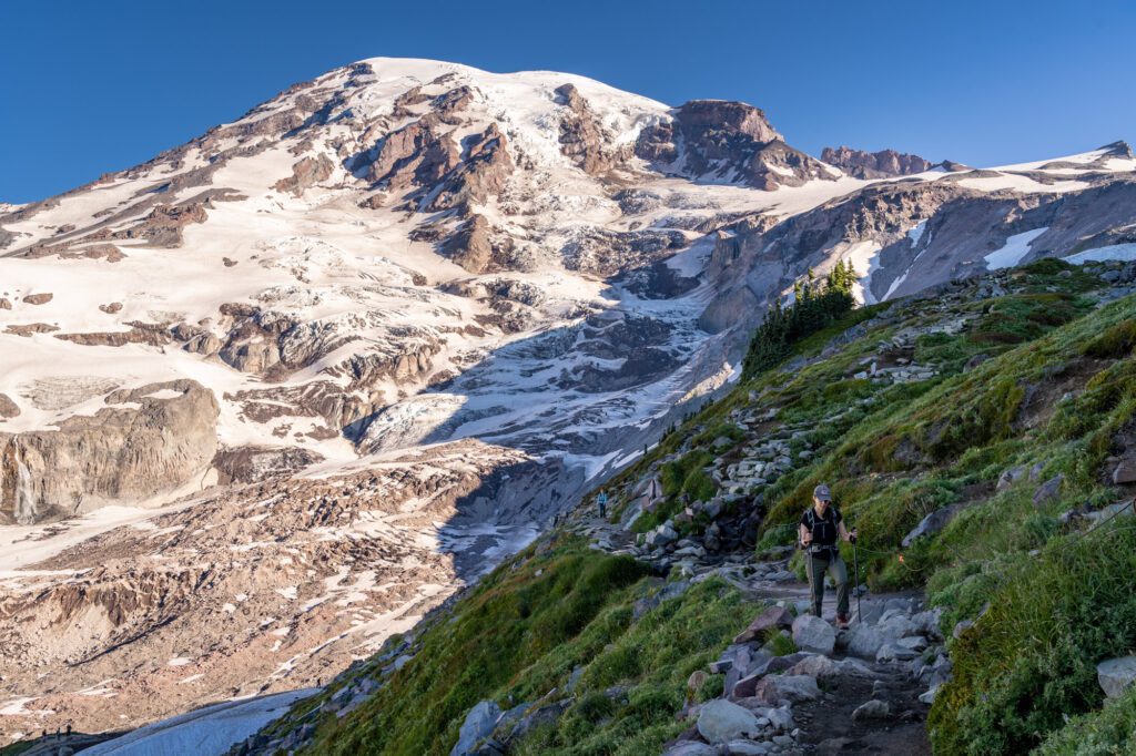
You’ll climb to Panorama Point, where you’ll have an unparalleled view of Rainier and the surrounding Tatoosh Range and Mount Adams.
It’s a great hike, and we have an entire guide dedicated to giving you all of the information you need to hike the Skyline Trail. Read that for more detail, like which direction to hike and what to expect along the trail.
The shorter, easier Nisqually Vista Trail or Bench and Snow Lakes Trail would be good alternatives if you’re not confident in your ability to do the Skyline Trail.
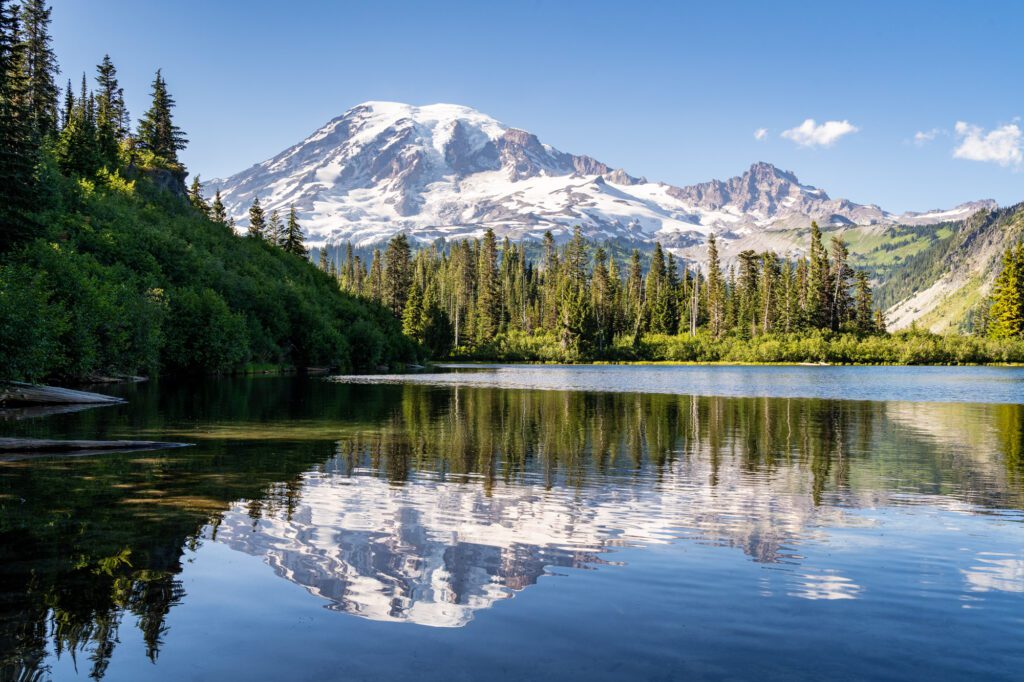
Visit Reflection Lakes: This is a great spot with a picture-perfect reflection of Mount Rainier in the water of the lake. It’s very popular with humans and mosquitoes alike, especially in the summer. Stop here for a spectacular sunrise or sunset.
Admire the Waterfalls: This part of the park is full of gorgeous waterfalls.
The easiest to access are Narada (here on Google Maps) and Christine (here on Google Maps), which are basically just off the road.
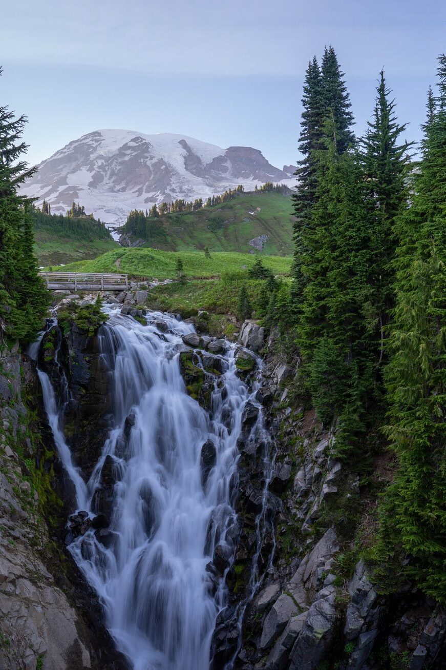
Myrtle Falls – our favorite of the bunch (here on Google Maps) – is a half mile hike from the main parking lot along a paved trail, and Comet Falls (here on Google Maps) involves a four mile hike.
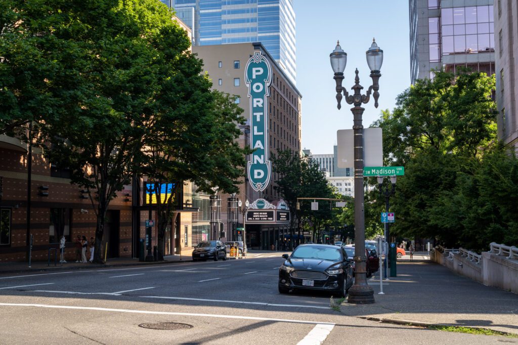
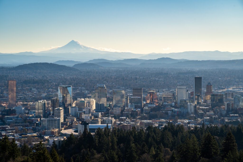
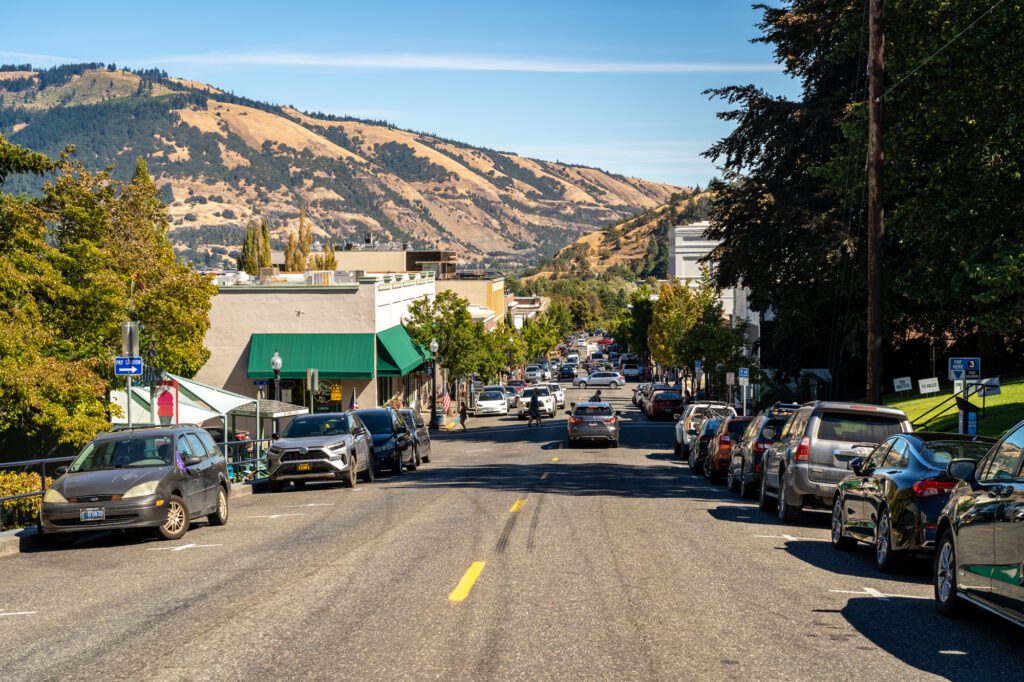
Portland, Oregon
Drive time from Paradise: 3 hours / 160 miles
Ah, Portland! We love Portland, which is why we decided to relocate here a few years ago after nearly a decade of talking about it.
Portland takes the things we love about living in Seattle and San Francisco and makes them better because the cost of living is (slightly) lower, which means there is more opportunity for innovation from local artists, chefs, and other small businesses that just doesn’t exist in places where it costs a million dollars to do anything.
Specifically, Portland has unrivaled access to nature and green spaces in the city center, a thriving food and drink scene with a surprisingly diverse set of offerings (given the fact that Portland is NOT diverse), and access to both the ocean and the mountains within 90 minutes or so.
Now, if you’re on a road trip, chances are you’re looking to spend most of your time outside of major cities. Which we totally get.
However, we’d strongly recommend a stop in Portland for a meal, at the very least. Specifically, a meal at a food truck!
Here are a few things to do that we think are worth your time, even if it’s limited. For more, definitely read our guide to the best things to do in Portland.
Powell’s Books: Powell’s is the biggest independent bookstore in the world! We take all visitors here, and regularly visit ourselves. It’s worth going to their flagship in downtown Portland, which is a massive multi-story building full of books from all genres.
Eat at a Food Cart Pod: Portland is famous for its food cart pods, which are somewhat unique and offer a really important part of Portland’s food scene: a lower cost way to try a concept without investing in a full restaurant.

Take a look at many of Portland’s hottest restaurants and you’ll find that they actually started as a food truck, slowly expanding their empire into brick and mortar.
It’s cool, and it’s part of what makes Portland such an interesting food city.
Our favorite pods in the city are the Prost! pod near Mississippi Avenue in NE Portland (we used to live nearby) and Hawthorne Asylum in the Central Eastside.
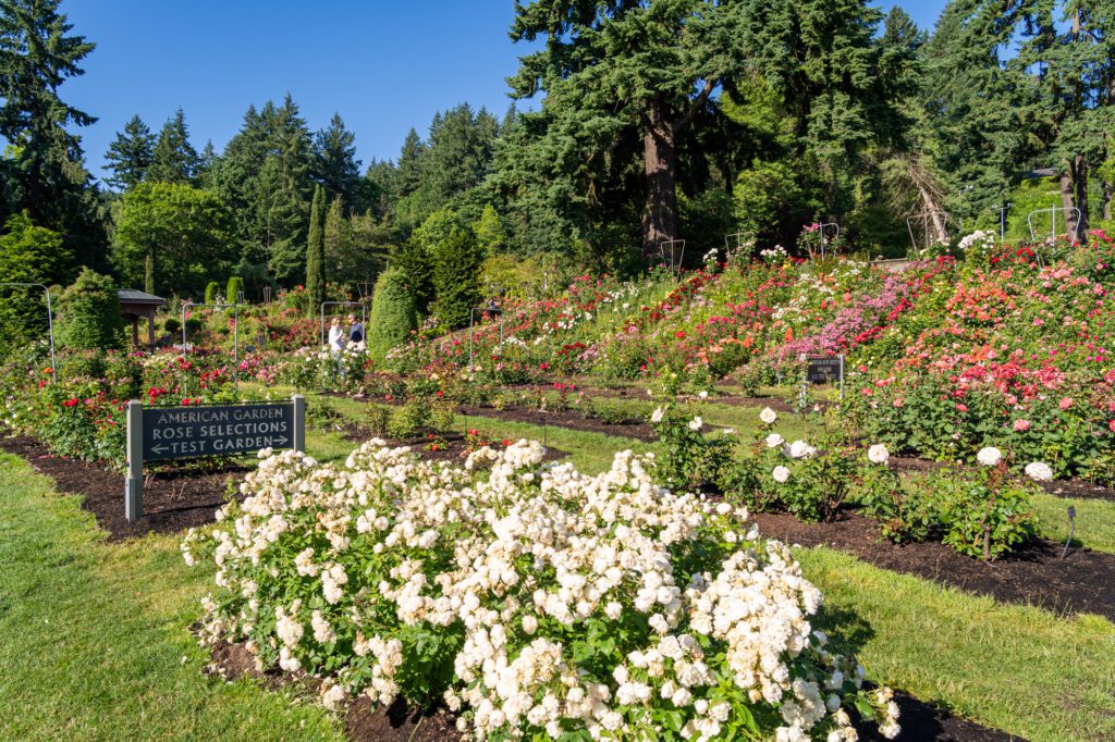
The International Rose Test Garden: Stop and smell a massive amount of breathtaking roses at the International Rose Test Garden, which has 10,000 buds that bloom from late May to October, roughly. Great views of Portland and Mt. Hood (on a clear day) too!
Eat Some Doughnuts: For doughnuts, which are a must-try in Portland, a city full of artisanal donut shops, enjoy delicious donuts at Pips Original (sadly not gluten-free, but they offer chai flights, need we say more?), Blue Star (also not gluten-free), or Petunia’s (100% gluten-free!).
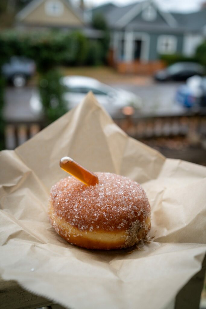

You’ll notice that we skipped Voodoo, the most famous doughnut spot in Portland, which has average doughnuts, but does deliver on the Portland vibe (though they have a location at Disney World these days).
If you MUST go to Voodoo, go to the one on the east side of the river (here on Google Maps), which is a much more pleasant experience.
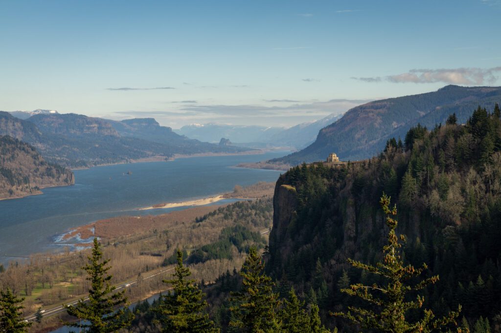
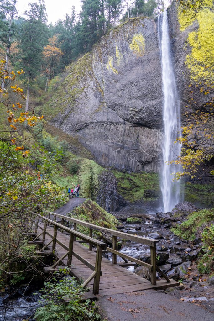
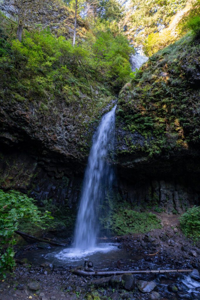
The Columbia River Gorge
We’re not including drive time here, because it starts just after you leave Portland, and ends in Hood River.
In this section, we’re going to give you a route between Hood River and Portland that has you enjoying our favorite stops in the Columbia River Gorge.
The drive between Hood River and Portland is about an hour, but with all the stops to make along the way, it will take you at least a half day to complete. You’ll see three waterfalls along the way, which is what the Gorge is arguably most famous for.
The Vista House and Women’s Forum Viewpoint: Both along the Historic Columbia River Highway, these are two of the best views of the Gorge you’ll find anywhere.
The Vista House is here, and just a bit further up the road, the Women’s Forum Viewpoint is here.
Latourell Falls: A quick and easy waterfall hike that takes you up to the upper falls, then loops down around, crossing under the highway to bring you to the base of the more spectacular lower falls.
Don’t settle for the view from the parking lot, it’s worth doing the short hike! More trail information here.
Multnomah Falls: While this is the most famous waterfall in Oregon, it’s not our favorite. That’s not to say that it’s not spectacular – it absolutely is – but it’s SO CROWDED.
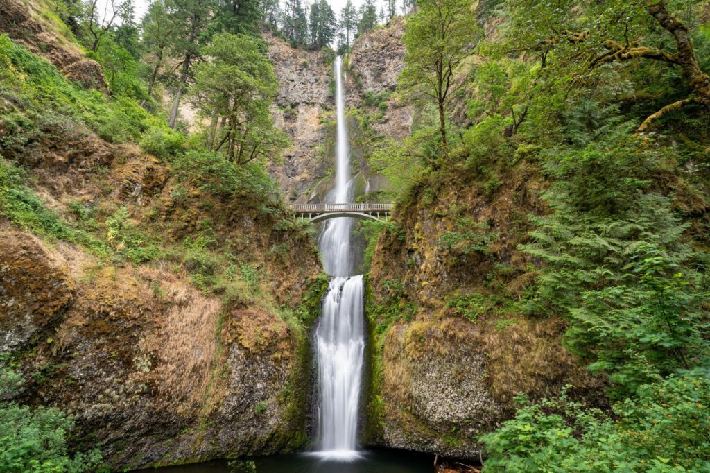
You should get out and see the waterfall, but there are better waterfall hikes nearby to tackle instead.
If you’re looking for a less visited waterfall, head to Dry Creek Falls, which intersects with the Pacific Crest Trail and ends at a nice waterfall with far fewer visitors.
Horsetail and Ponytail Falls: A little bit further down the Historic Columbia River Highway are two of our favorite waterfalls in the Gorge – Horsetail and Ponytail.
Horsetail is visible from the parking lot, and you can do a quick half mile hike up to Ponytail, where you can walk back behind the falls, which is cool.
If you’re looking for more, you should read our guide to the best hikes in the Columbia River Gorge, which covers every hike we’ve done between Portland and Hood River (there are a lot of them!).
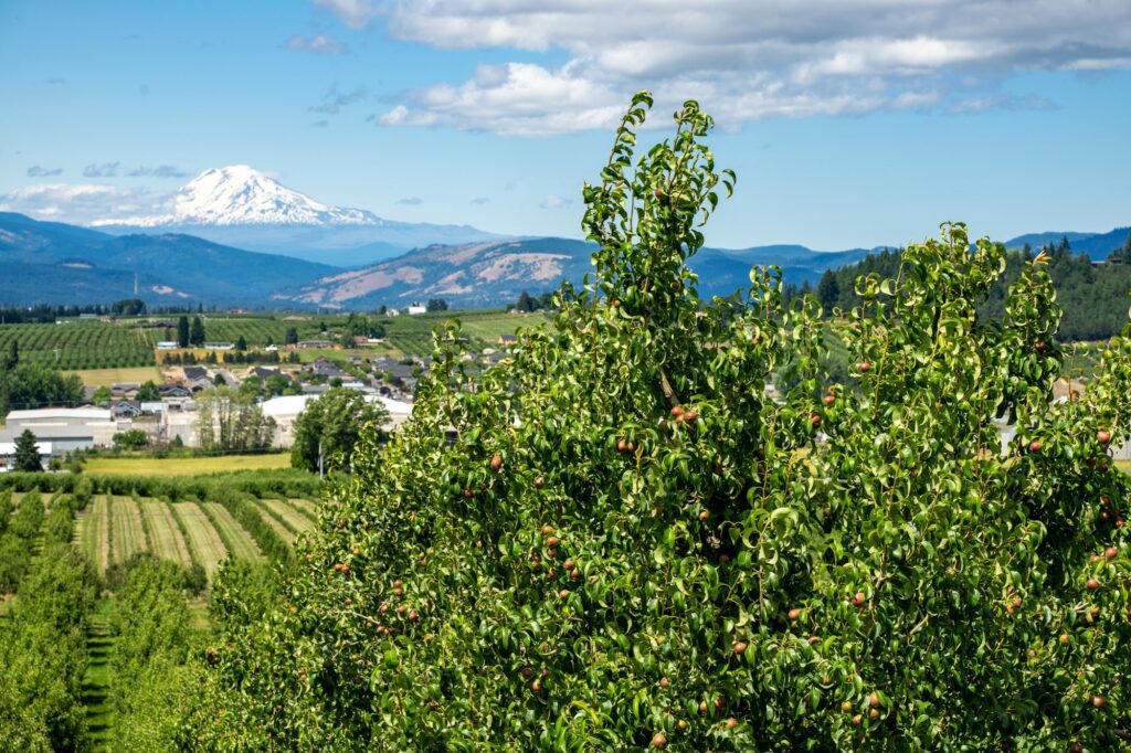
Hood River
Drive time from Portland: 1 hour / 63 miles
Hood River is a charming town in the Columbia River Gorge that generally marks the point where the landscape turns from the temperate, wetter climate of western Oregon to the drier, warmer climate of the central and eastern parts of the state.
The town is known for windsurfing thanks to its position right on the Columbia River Gorge. The wind whips through the gorge and creates an ideal pocket for windsurfers.
As you drive towards Hood River from Portland, you’re likely to see a bunch of windsurfers on the water on days where the conditions are right.
It sits on the northern edge of one of the most fertile areas in all of Oregon. Cherries, apples, pears, and grapes all grow here with great success, and it’s a perfect area to sample local produce.
Here are some things not to miss in Hood River – we’re not including activities in the Columbia River Gorge here, because we have a whole section on that above.
Drive the Fruit Loop: Speaking of amazing produce, the Hood River Fruit Loop is just south of town, and you’ll drive right through it as you head towards Mount Hood (the next stop).
This is where the apple trees grow as far as the eye can see, backed by jaw-dropping views of Mount Adams, Mount Hood, and Mount St. Helens.
Stop by Hood River Lavender Farms during the summer to see blooms of purple lavender in the foreground, with Mount Hood in the background.
Draper Girls Country Farm is the place to go for farm-fresh (and u-pick) produce, including cherries in the summertime.
And the Gorge White House is a nice stop for lunch, wine, or cider in a gorgeous setting.
Drink at a brewery in town: There are a couple of famous breweries in Hood River that were among the first craft breweries in Oregon. Full Sail has a taproom right in downtown Hood River, and Double Mountain Brewery is just a few blocks away, making it easy for you to hit both and decide which is your favorite.
Wine tasting: Though not as famous as the Willamette Valley, the area around Hood River produces some pretty solid wine. We really like the wine on the Washington side from Loop de Loop, who have a very cute winery dog and a great view of Mount Hood from the vineyard.
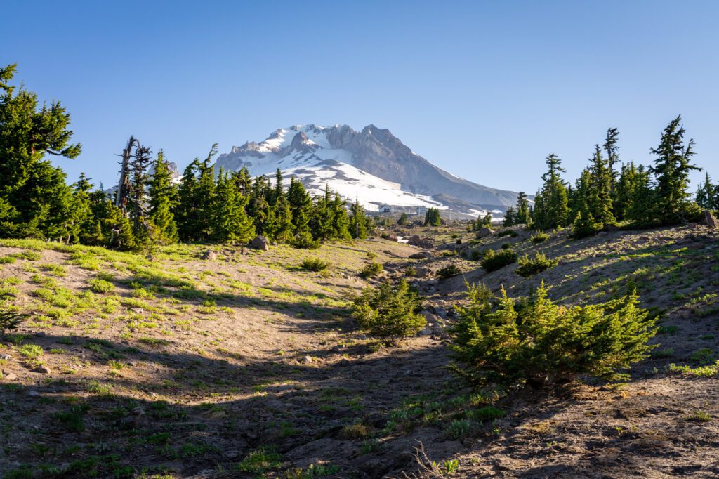
Mount Hood (Government Camp)
Drive time from Hood River: 45 minutes / 42 miles
Mount Hood is our favorite hiking spot near Portland, and you’ll find us up here every single summer.
In a lot of ways, Portland’s relationship to Mount Hood is similar to Seattle’s to Mount Rainier in that it’s one of the most popular outdoor destinations near the city and it’s a barometer of how nice the weather is (whether or not you can see the mountain).
If you’re coming from Hood River, you’ll be approaching Mount Hood from the eastern side, driving up Highway 35, which skirts the eastern face of Hood.
Which puts you in the perfect position to stop and tackle one of our favorite hikes in the state, Tamanawas Falls.
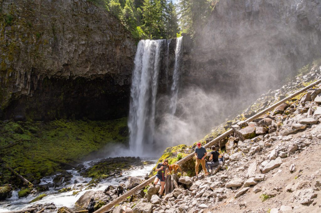
It’s a great waterfall hike, it’s accessible in terms of difficulty, and it’s right off the side of the highway.
The vast majority of the things to do and see at Mount Hood are around the southern side of the mountain, near the town of Government Camp.
It’s a ~15-20 minute detour from your route, and we think it’s worth it if you’re looking for a) some of the best hiking on this entire route and b) one of the most picturesque lakes in the state.
In terms of hiking, you have lots of options near Government Camp.
Our favorite hikes here are Tom, Dick, and Harry Mountain, which climbs to the summit of one of the mountains across the valley from Hood with a magnificent view looking back at the mountain, and the hike to Bald Mountain from Lolo Pass, which ends at another jaw dropping view of Hood.
There’s also McNeil Point, which is a brutal climb up to one of the highest points you can reach on foot. That’s a full day excursion though, and it’s probably best for a trip where you have more than a day in the area.
We also really enjoy the majestic and historic Timberline Lodge, which is a century old and feels like a relic from a different time.
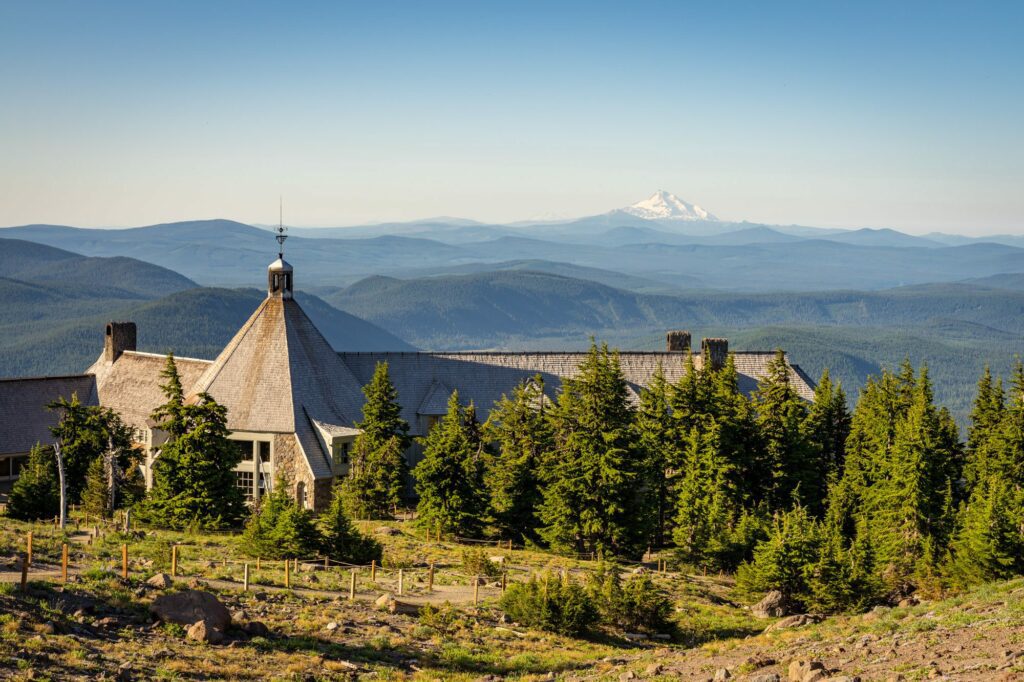
It’s perched high up on the slopes of Mount Hood’s southern face, and is a great ski destination in the winter, and an equally great hiking destination in the summer and fall.
Timberline Lodge to Zigzag Canyon is a great, relatively easy hike that traverses both ski runs and the Pacific Crest Trail en route to a spectacular view of Hood.
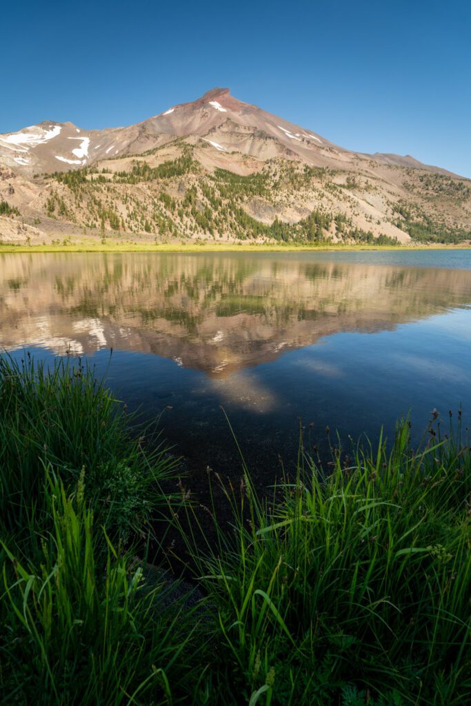
The last place we’d call out here is the aforementioned lake with an unbeatable view, which is called Trillium Lake.
We’ve camped here almost every summer for the past several years, and the view from the far end of the lake looking back at Hood is one of our favorites (roughly here on Google Maps).
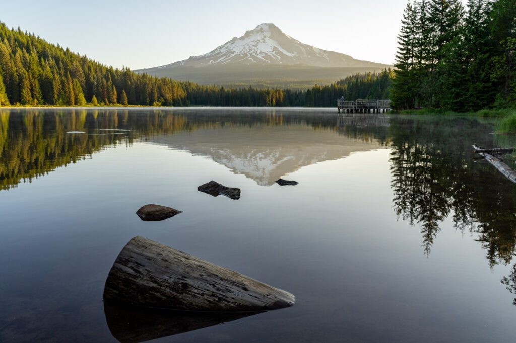
We even have that photo, which we took here at sunrise a few years ago, framed on the wall of our living room in Portland.
If you’re looking for more, head straight to our guide to the best hikes at Mount Hood (we’ve done almost all of them!).
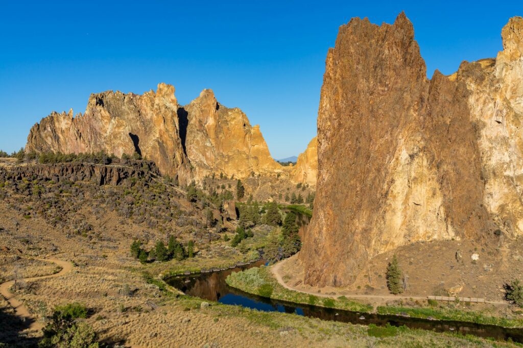
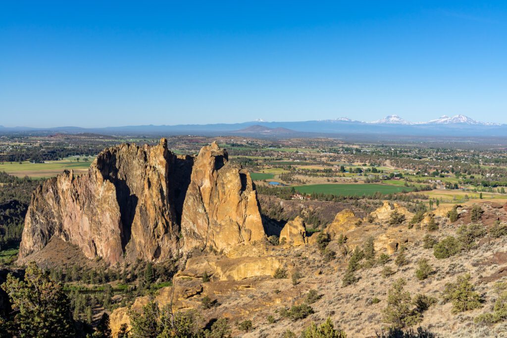
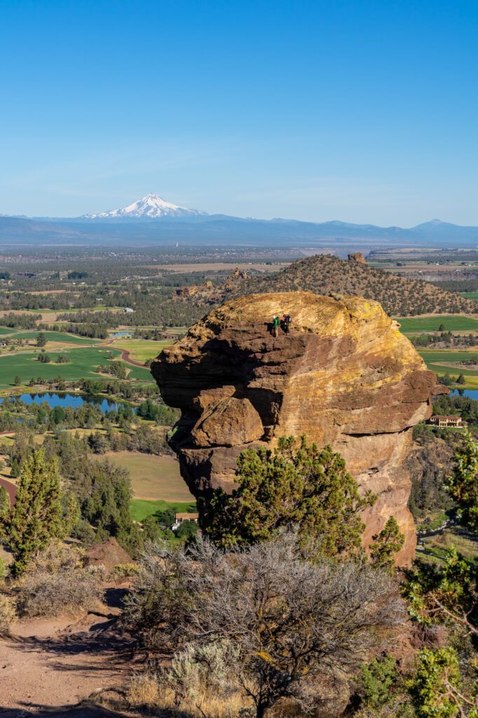
Smith Rock State Park
Drive time from Government Camp: 1 hours 45 minutes / 85 miles
Just north of Bend in the town of Terrebonne, you’ll find Smith Rock State Park.
We like Smith Rock because, while Bend still feels vaguely like it’s in the mountains, Smith Rock State Park is much more indicative of the types of landscapes you find in central and eastern Oregon. The high desert.
Towering rock formations, dry and dusty, with a dose of rattlesnakes. That’s the high desert for you.
It’s a beautiful park, with a winding river snaking (ha!) its way through deep, rocky canyons.
It also happens to make a great stop between Mount Hood and Bend, which is your next destination as you head south. You only need a few hours to see it, and you can continue south after a jaunt in the high desert.
There’s exactly one thing we think is a must-do here, and it’s hiking the Misery Ridge Trail.
There are two different versions of this hike, but both of them involve a steep climb to ascend to the ridge, and then a similarly steep descent past Monkey Face – a famous climbing destination that looks like a monkey’s face from a certain angle – where you’ll hit a trail junction.
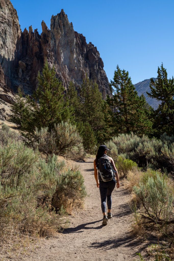
From that trail junction, a right puts you on the Summit Trail, which is a longer, harder, but more beautiful hike up and around the rim of the canyon.
A left puts you on the River Trail, which is a shorter, easier, mostly flat walk along the river back to the parking lot.
We prefer the longer version, but both are beautiful. It will be hot in the summer, so make sure to bring lots of water and sunscreen with you on your hike.
Bend, Oregon
Drive time from Smith Rock: 30 minutes / 26 miles
We love Bend, and try to make it a priority to visit at least once a year. It’s not really much of a secret anymore (or if it is, it’s the worst-kept secret ever), but Bend is one of the best adventure towns on the west coast, if not the entire country.
Bend’s location on the eastern slopes of the Cascades puts it in a unique position.
It’s close to the mountains, which means great access to excellent hiking in the summer and skiing in the winter, but it’s at the start of the high desert, which is the primary landscape you’ll find in central Oregon when you venture east of the mountains.
In every direction, you’re likely to see snow-capped peaks like the Three Sisters, Mount Jefferson, and Mount Bachelor (among others).
However, from Bend and to the east, you’ve got a quite different landscape; Oregon’s high desert.
It’s drier. It’s more extreme. And it’s a nice contrast from the wet, temperate climates in the western halves of Oregon and Washington.
The Deschutes River runs directly through Bend, creating a playground for lovers of water sports like kayaking and paddleboarding, and Bend’s Downtown and Old Mill District are full of great local restaurants and breweries, the latter of which the town has become famous for over the past decade or two.
Here is a quick summary of our top picks in Bend, but you should head over to read our guide to the best things to do in Bend for more detail and ideas.
If you’re into hiking, you’ll want to read our guide to the best hikes in Bend too.
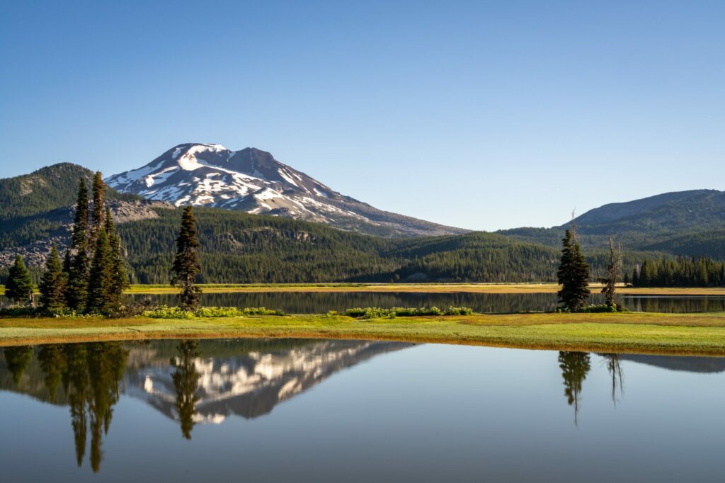
Cascade Lakes National Scenic Byway: This is the premier hiking destination in Central Oregon, we think. Every single hike we’ve done here (and we’ve done a lot of them) is a banger.
We love the Green Lakes Trail, which is perhaps the best bang-for-your-buck in the state, and the Tam McArthur Rim Trail to Broken Hand, which is just nonstop alpine paradise.
Both are in our top three favorite hikes in Oregon (though Tam McArthur is not quite along the Cascade Lakes Byway, it just accesses the same area from the other side of the ridge).
The Tumalo Mountain Trail is also nice, and it doesn’t require a Central Cascades Wilderness Permit in the summer (the other trails mentioned do).
Last, but certainly not least, head to Sparks Lake (here on Google Maps) for watersports and one of our favorite photo spots in Oregon.
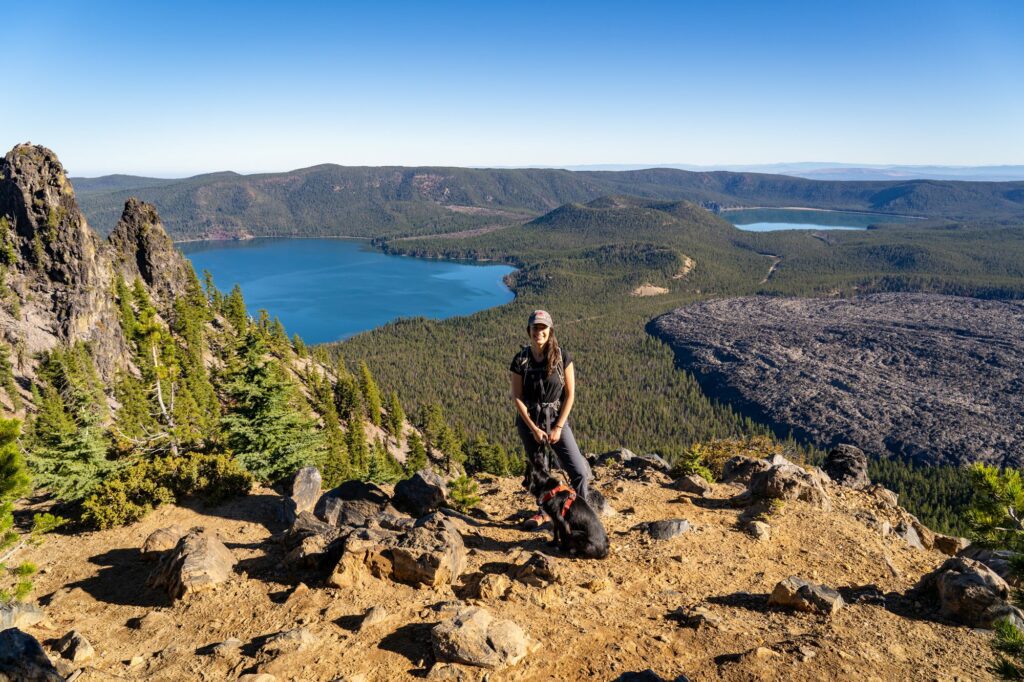
Newberry National Volcanic Monument: This is the volcano that shaped the high desert in Central Oregon, and it’s almost a mini-Crater Lake in terms of how it was formed and how it looks today.
There are two parts of the monument, and they’re about 30 minutes apart.
The first you’ll encounter heading south from Bend is the Lava Lands Visitor Center, which is where you’ll find the Trail of the Molten Land (walk through a lava field!) and Lava Butte.
Continue South to Paulina Lake and the Newberry Volcano, where you’ll find a large lake, the hike up to Paulina Peak (which features incredible views over the surrounding landscape, including the vast lava fields), and Paulina Falls.
Experience the Deschutes: The Deschutes River is, and has been, the lifeblood of Bend since its inception.
There are various ways to experience the river, depending on what you’re into and what the weather is like.
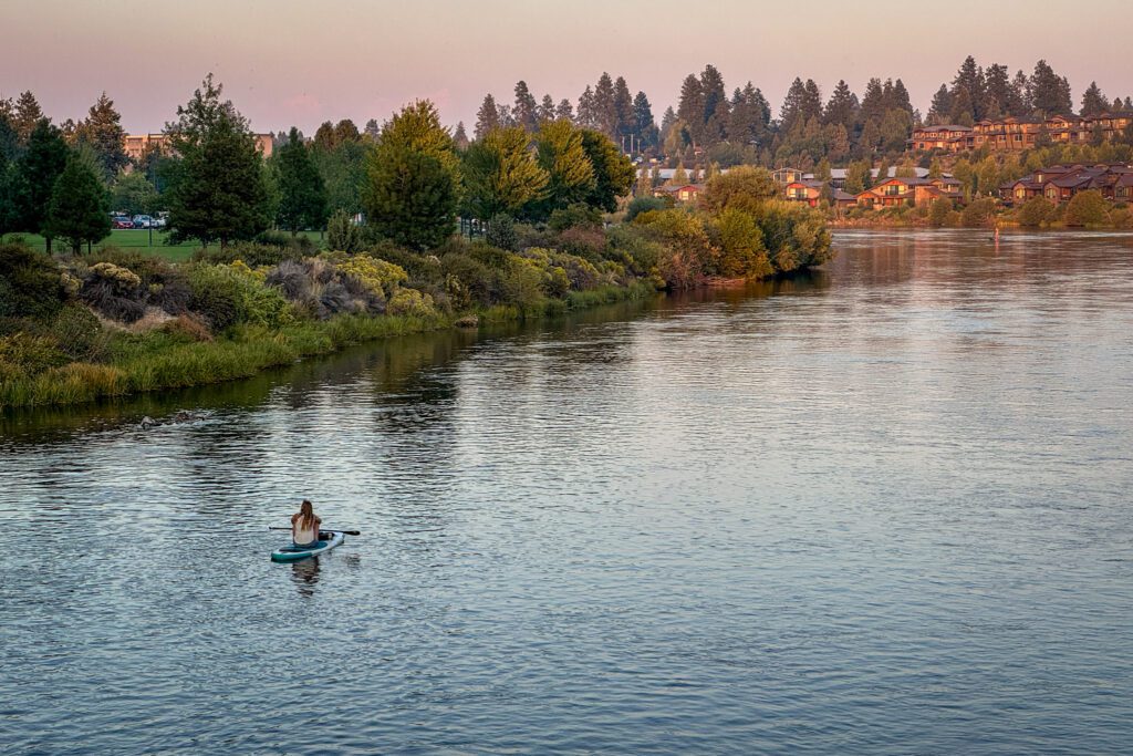
Escape the summer heat by jumping in the river with a tube and spending the day on a leisurely float. You could also do it via kayak or SUP (stand up paddleboard), depending on what you’re up for. More information here.
If getting in the water isn’t your thing, we love hiking along the banks of the river (we stayed near the river on our last trip and found ourselves along the river every day).
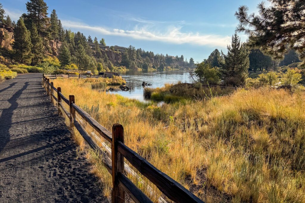
Two good options are the basic loop from Riverbend Park and the hike from Tumalo State Park to Riley Ranch.
Where to eat in Bend: You’ve got plenty of options in Bend (including just heading to a brewery and ordering their food).
Head to the Lot, a food cart pod on the west side of the river, with a bunch of different food trucks and carts for you to choose from.
Go to El Sancho Taco Shop for, well, tacos.
Spork is our favorite spot, and is a fusion restaurant with unique takes on a variety of different kinds of food.
For brunch, head downtown to the extremely popular Lemon Tree.
Hit the breweries: When it comes to drinking, Bend is known for its breweries (though there are two good cideries in nearby Tumalo that we like – Tumalo Cider and Bend Cider Co.).
Crux Fermentation Project has a lovely outdoor space, perfect for relaxing in the sun with a pint in the summer.
Bend Brewing Co. has a nice outdoor space near Downtown and the river.
Silver Moon Brewing has a fun trivia night on Thursday nights that’s worth stopping by.
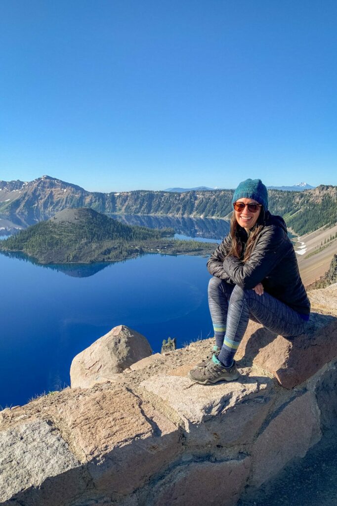
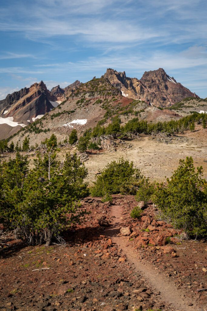
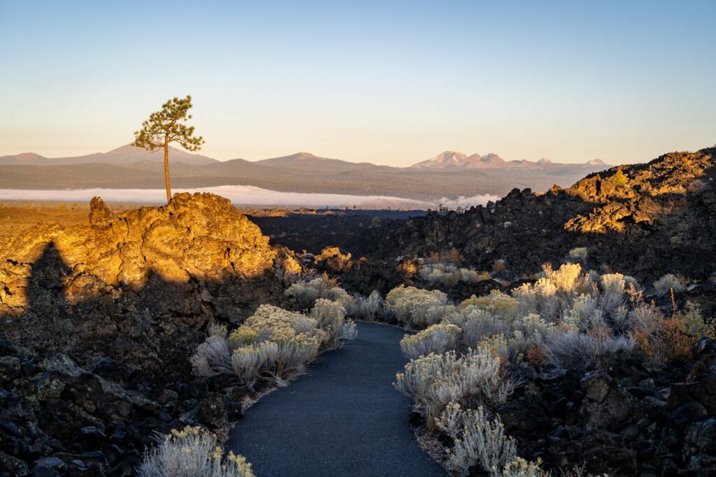
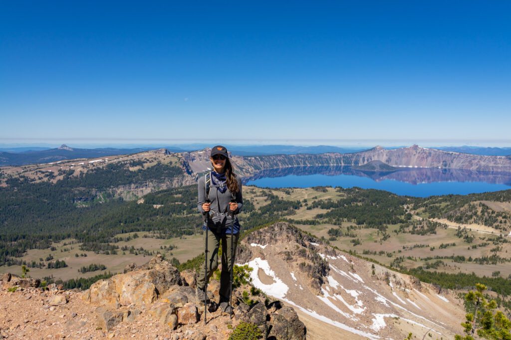
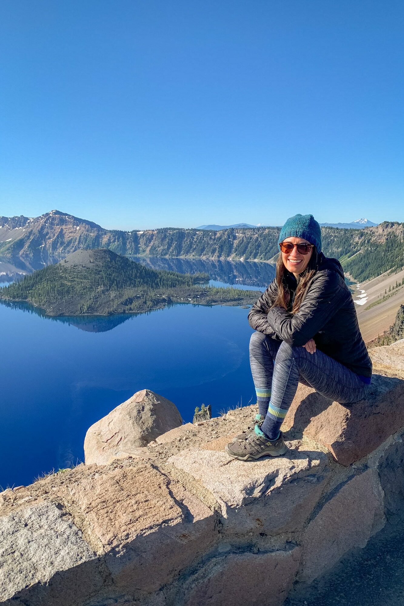
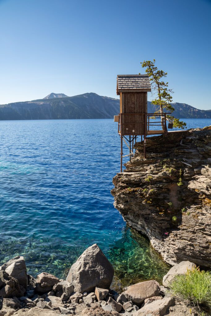
Crater Lake National Park
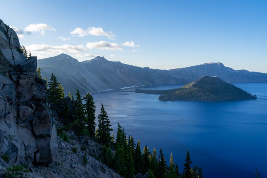
Drive time from Bend to the South Rim: 2 hours / 110 miles
Formed almost 8,000 years ago, Crater Lake is the result of the eruption of Mount Mazama, which used to stand where the crater is today. The eruption caused the volcano to collapse, and here we are.
We think this stop is worth a day or less on your road trip. It’s beautiful, but there’s really only a couple of things to do in the area, and anything more than a day is probably better spent elsewhere.
Heads up: There are very, very few places to stay near Crater Lake. There are the campgrounds – Mazama Campground is the main one – and there’s the Crater Lake Lodge. Other than that, there’s not a whole lot. Book early!
Here are our favorite things to do at Crater Lake.
Drive the Rim Road: The road around the rim of the lake is 33 miles long, and we think you should make an effort to drive the entire thing, making stops along the way and marveling at the sapphire blue water of the lake from all sorts of different angles.
The drive is best before 9:00 am, when the traffic on the road starts to build and it becomes a whole lot harder to find parking at the various pullouts.
The road around the eastern edge of the lake opens in the summer and closes during the fall – check road conditions here.
It’s worth noting (again) that during the winter, the access road from the northern side is closed (which is where you’d be coming from if you’re visiting from Bend) which would mean you have to drive all the way around.
Hike to the highest and lowest points in the park: There are a couple of hikes we think are worth doing at Crater Lake.
Mount Scott takes you to the highest point in the park for fantastic views of the lake and surrounding area.
Cleetwood Cove is the only place in the park where you can get down to the water level. Both are fantastic.
Watch the sunset from the rim: Close out your day by watching the sun set from the rim. We have spent sunsets at Cloudcap Overlook (here on Google Maps), which is on the east side of the lake facing the setting sun.
Get there an hour before sunset for a prime parking spot.
The other spot to go for sunset is Garfield Peak, which involves a steep 3.4 mile hike to a viewpoint with a great view of the lake and the setting sun.
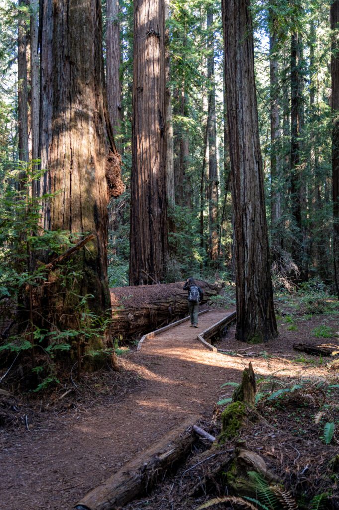
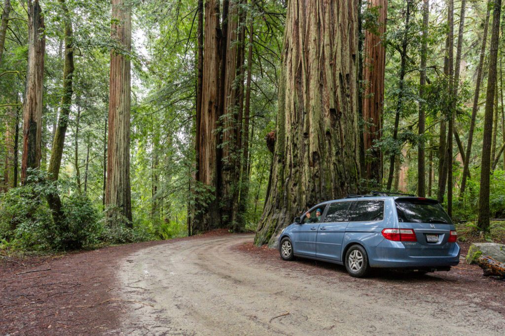
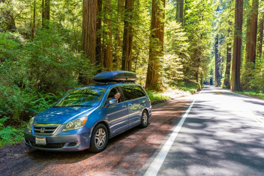
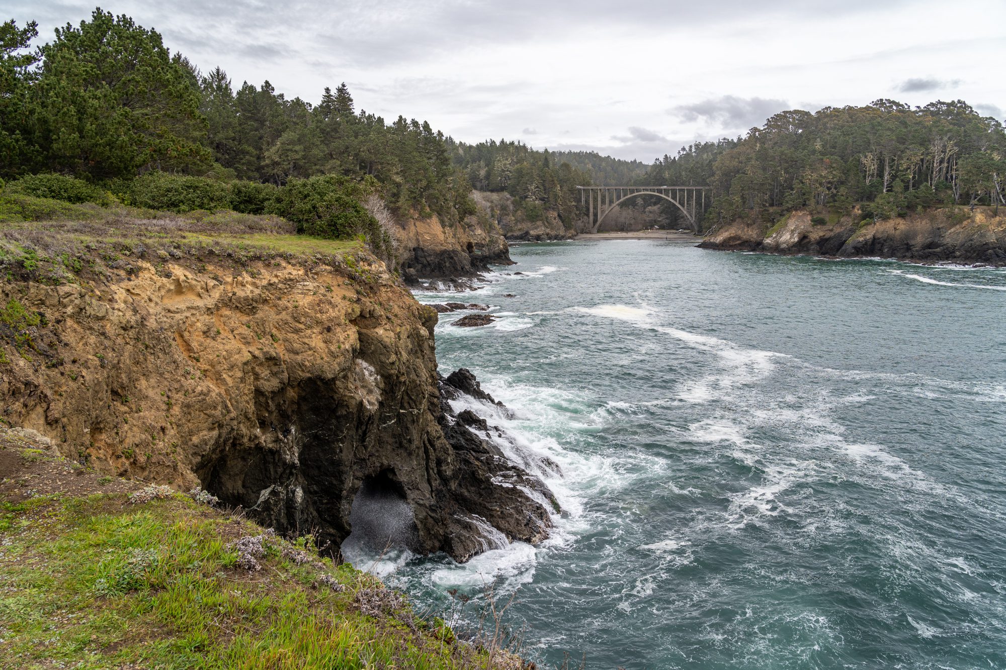
Redwood National and State Parks (Trinidad)
Drive time from Crater Lake’s South Rim: 5 hours / 230 miles
And finally, you’ve made it to California!
Getting to the coast from Crater Lake involves a long drive, but it’s worth it. You’ll head west from Crater Lake to get back to I-5, then continue on towards the coast on Highway 199, which leaves from Grants Pass and meets up with 101 near Crescent City, California.
Your next destination is a complex of national and state parks – Redwood National and State Parks – which, collectively, are the best place in the world to see towering coastal redwoods.
What exactly is included in this complex of parks, you ask? It includes Redwood National Park and three California State Parks – Del Norte Coast, Jedediah Smith, and Prairie Creek – forming a complex that is prime redwood territory.
The complex was protected under the National Park Service through activism by the Save the Redwoods League, who fought to preserve the best example of coastal redwoods in the state against the desire of logging companies.
The best home base for exploring the far reaches of the Northern California coast is the small town of Trinidad, which puts you 30-45 minutes from most of the stops in the redwoods.
However, it also puts you near a bunch of great coastal hikes and beaches, like the loop at Trinidad Head, College Cove, and Moonstone Beach.
Whenever we’re staying in this part of the world, we stay at the excellent View Crest Lodge, which has units with kitchens and is right across the street from a nice state park.

Howland Hill Road: Drive through the redwoods – and we really mean that – along this 10 mile long stretch that used to be a stagecoach road.
It’s narrow, but it’s about as up-close-and-personal as you can get to the redwoods.
We drove it in our minivan in the winter, and it wasn’t bad at all – should be suitable for most (if not all) vehicles. More information here.
Stout Memorial Grove: A short, beautiful hike featuring huge redwoods that were used in various movies, from Return of the Jedi (keep an eye out for Ewoks!) to Jurassic Park.
The size of some of these trees, particularly the downed trees, is staggering. More information here.
Fern Canyon: The most famous hike in this part of the state, this hike starts at a trailhead that is hard to access in the wetter months, as rain can wash out the road.
If you’re doing this in the winter, you probably need a high-clearance vehicle.
The hike itself enters a canyon that is, you guessed it, full of ferns. Like, ferns lining the walls of the canyon top to bottom. It’s surreal, and feels like it should be in a Jurassic Park movie.
Can’t access the trailhead because of the washed out road? Here’s an alternate route that takes you into the canyon from the end of the well-maintained road.
Newton B. Drury Scenic Parkway: Similar to Avenue of the Giants (the next stop), this scenic drive takes you parallel to 101 through Prairie Creek State Park and a nice string of redwoods.
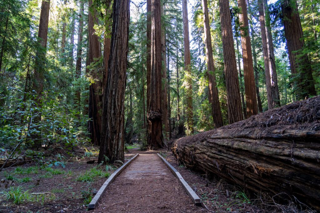
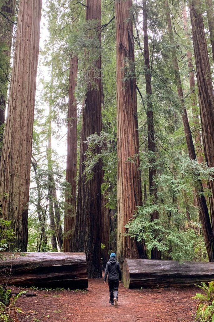
Avenue of the Giants
Drive time from Trinidad: 1 hours 20 minutes / 70 miles
While the Avenue of the Giants is basically parallel to 101, the main highway you’ve been driving on, it is truly a whole different world.
You’ll meander along a windy, two lane road through massive redwoods for 31 gorgeous miles.
It starts here, and there are countless points to pull over and walk into the redwoods that are often thousands of years old, marveling at their size.
Put on some good music, roll down the windows, and enjoy the drive.
For what it’s worth, we loved the Bull Creek Westside Loop, which is a three mile hike through the redwoods, with enough up and down to get the blood pumping after a long drive.
Mendocino
Drive time from the Avenue of the Giants: 2 hours 30 minutes / 100 miles
This is a long drive, but it’s not like there aren’t stops to make along the way.
This is the part of the journey south where you meet up with world-famous Highway 1 (don’t let Google Maps tell you to cut inland, which is slightly faster and far less scenic) south along the Northern California coast towards San Francisco.
Make your way down the coast to Mendocino, a lovely little town on the Northern California coast, perched on a bluff over the Pacific Ocean.
We’re going to include Fort Bragg in this section too, which is a small town just a few minutes north of Mendocino.
Here are some of our favorite things to do on this stretch of beautiful California coast.
Hike the Mendocino Headlands: The Mendocino Headlands Trail takes you out onto the bluffs where Big River (creative name) meets Mendocino Bay and, ultimately, the Pacific Ocean.
The short, easy hike makes a loop along the bluffs on the southwest side of town, and is a perfect location for a morning stroll.
Afterwards, grab breakfast in town at the Good Life Cafe and Bakery or Cafe Beaujolais.
Explore Russian Gulch State Park: This sliver of land that comes inland from the coast is a gorgeous setting for an afternoon stroll in the woods.
Do this lollipop hike starting from the western entrance, making your way up the canyon, and doing the waterfall loop at the eastern end of the park.
There’s also a shorter loop that focuses on the area around the waterfall. Fern Canyon (a different Fern Canyon) is another good redwood hike, just south of Mendocino.
Go wine tasting in the Anderson Valley: Alysha took me to Mendocino for my birthday a few years ago, and one of our favorite things we did was wine tasting in the Anderson Valley, which is ~40 minutes inland from Mendocino.
In a part of the country known for amazing wine, we’re used to having to fork over at least $20 for three tiny pours of wine, which we inevitably split to save money.
Not so in the Anderson Valley! It’s more affordable, and the wines are a better fit for our palates (we prefer light and fruity reds and whites to big and bold, which is what Napa is known for).
We loved Roederer Estate for bubbles, and Navarro for the setting (and their Gewurztraminer is great, too).
Hendy Woods State Park is worth a stop out there too, for the redwoods.
Explore Glass Beach and Point Cabrillo: These are both quick stops north of Mendocino towards Fort Bragg.
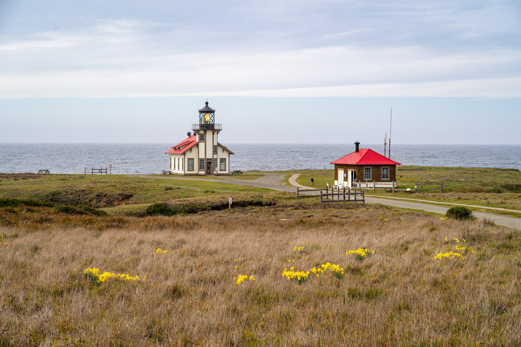
Point Cabrillo is home to a nice lighthouse and some coastal hiking trails.
Glass Beach is a cool beach made of sea glass rather than sand (here on Google Maps).
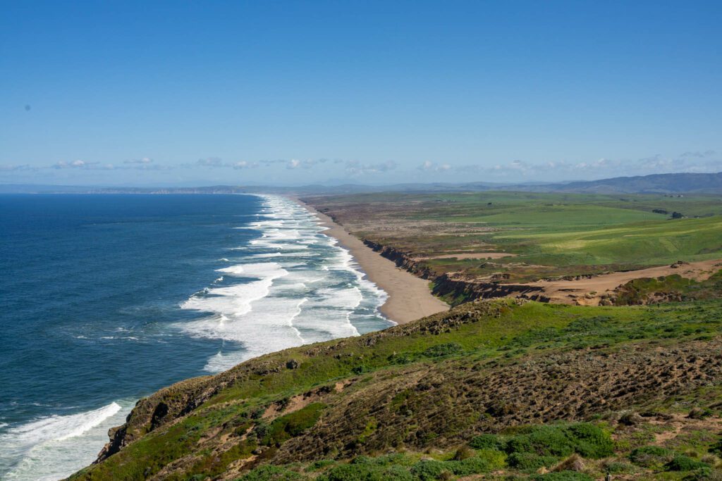
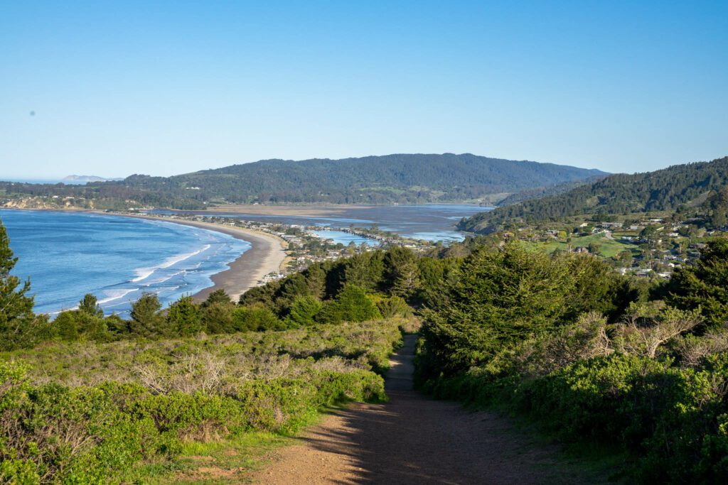
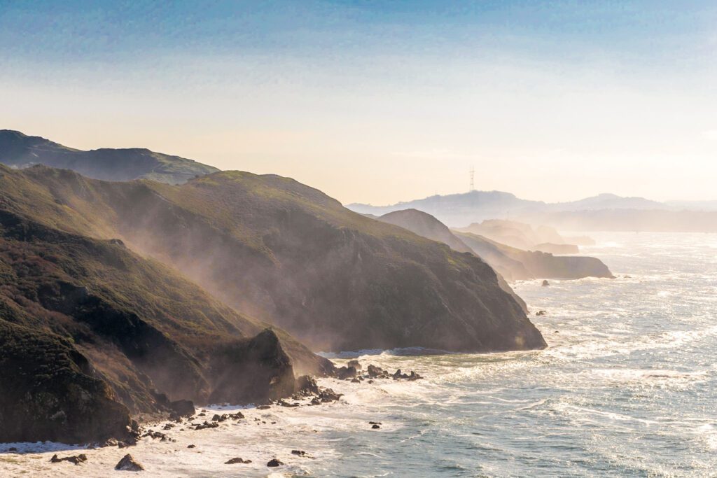
Point Reyes National Seashore
Drive time from Mendocino: 2 hours 45 minutes / 135 miles
Today is a long driving day, with about three hours (and 135 miles) of sheer coastal California beauty waiting for you between Mendocino and Point Reyes.
There are plenty of places to get out and stretch your legs along the way. However, with limited time, we would recommend just a stop rather than spending an entire day or night here – you’ve got a long way to go!
Some good stops to make are the charming seaside town of Bodega Bay, Wright’s Beach and Sonoma Coast State Park, and Jenner Beach, to name a few.
Point Reyes is a big peninsula that juts out into the Pacific, separated from mainland California by Tomales Bay. There are two main places to explore here – on the peninsula, and in the town of Point Reyes.
You should know that the drive time / distance above gets you to the town of Point Reyes Station, which is a charming small town that’s definitely worth a stop, but the real fun starts after another 45 minute drive out to the coast.
That drive is full of rolling hills, pastoral scenes featuring barns and cows, and coastal views as you approach your destination.
We’re biased, because Alysha grew up about 30 minutes away from here, but we think this is going to be among the most stunning places you visit in Northern California.
From December to May, this is prime whale watching territory. We’ve seen migrating gray whales frolicking in the shallow waters just below the Point Reyes Lighthouse before.
Here are some things to do in and around Point Reyes.
Visit the Point Reyes Lighthouse: A gorgeous lighthouse set into a cliff, accessed via a steep set of stairs.
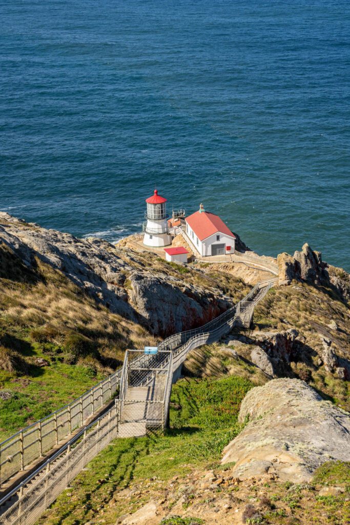
This is one of our favorite lighthouses in California, and probably on the west coast. It’s a long drive to get there, but we think it’s worth it. More information here.
Hike the Tomales Point Trail to see some Elk: The Tomales Point Trail is an excellent hike for stunning coastal views and, surprisingly to some, elk.
There’s a relatively big tule elk population that calls the peninsula home, and this hike is one of the best places to see them.
The last time we did this trail, we came across numerous elk along the trail, including a cute mama and baby elk that were just hanging out, grazing with a view.
It’s a long hike out to the northern tip of the peninsula, but you can do a portion of the trail to get a feel for the landscape and wildlife.
Explore Point Reyes Station: Point Reyes Station is a cute little town with a surprisingly high number of good places to eat and drink.
The two best are Brick Maiden Breads, a famous bakery that is an excellent place to grab either pastries – sweet and savory – or ready-to-eat lunches like sandwiches and salads, and Bovine Bakery, who makes Alysha’s favorite Bear Claw (among other pastries).
Eat oysters on Tomales Bay: Tomales Bay is famous for its oysters, and you can enjoy them fresh at various places along the shores of the bay.
Hog Island Oyster Co is the most famous, and is our pick. They have an oyster bar about half way up Tomales Bay from Point Reyes Station (here on Google Maps).
See the Cypress Tree Tunnel: You’ve likely seen pictures of the famous Cypress Tree Tunnel from your favorite photographers on Instagram.
The trees have grown over the road in a nice little canopy, and the light is particularly nice at sunrise and sunset, when the low angle of the sun means that the golden glow enters the canopy.
It’s on the way to the Lighthouse, and makes for a nice stop – here on Google Maps.
Mount Tamalpais & Around
Drive time from Point Reyes to the Mountain Home Inn: 45 minutes / 24 miles
If you thought you were going to be able to get to San Francisco without making several stops on your way into the city, you were mistaken.
Since we lived in San Francisco for nearly a decade, there are a bunch of places just outside the city that we have visited over and over again.
This is one of those places that we love, and this stop is for hiking enthusiasts.
A couple of the best hikes in the Bay Area are found in the area surrounding Mount Tam, and we’re going to give you three of our favorites.
The Dispea, Steep Ravine, and Matt Davis Loop: This might be our favorite hike in all of northern California.
It has it all – redwoods, babbling brooks, and coastal views.
Start from the parking area near Stinson Beach (here on Google Maps) and head downhill first before climbing back up.
The scenery changes drastically over the course of the hike, which makes it fun and interesting.
Cataract Falls: A moderate hike to a cascading waterfall, be aware that you’re hiking downhill on the way there, which means you’re going to be hiking uphill the entire way back.
Mountain Home Inn to East Peak: This is a hike we’ve done numerous times. Sure, you can totally drive to the parking lot at the East Peak, but where’s the fun in that?
The views are always better when you earn them, and this hike through the woods is the way to do just that.
From the top of Mount Tam’s East Peak, you can see the entirety of the Bay Area, sprawling out before you.
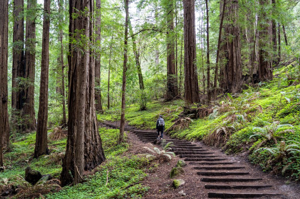
Muir Woods
Drive time from Mount Tam: 10 minutes / 3 miles
We went back and forth on whether or not to include Muir Woods on this itinerary at all.
Why? Because – SPOILER ALERT – you have already seen some pretty incredible redwoods on the Northern California coast, and we think they’re much more impressive than the ones you’ll find at Muir Woods.
But, we decided to give you the information so you can make that decision for yourself.
Muir Woods is a National Monument, and it was created to protect 240 acres of old growth redwoods, which used to be commonplace in the Bay Area but are, sadly, now relegated to just this little slice of paradise thanks to the logging industry.
Most of the trees here are somewhere between 500 and 800 years old.
There are two ways to access Muir Woods.
First is navigating the permit system, which is how they limit the number of people within the area.
You’ll need to either make a parking reservation in advance (which allows you to park right at Muir Woods, which has a small parking lot) OR make a shuttle reservation in advance, where you can park at a large parking lot and take a quick and easy shuttle to and from the park.
The shuttle is only available on weekends and holidays, but parking is much easier to get on weekdays so it shouldn’t be a problem if you plan in advance.
More information on the permit system here.
The second way to access Muir Woods is less known, and it involves some (beautiful) hiking.
This short hike from the Mountain Home Inn is the back door to Muir Woods.
You’ll start from atop the Panoramic Highway (which is a fun drive in its own right) and drop down into the forest, winding your way towards Muir Woods from the backside.
Whichever direction you do it, you’ll have a relatively steep uphill section to get back to your car. Make sure to get to the parking lot very, very early (especially on a weekend) because it’s tiny.
There is some parking along the highway, but it also fills up by 10:00 am or so.
The Marin Headlands
Drive time from Muir Woods: 30 minutes / 15 miles
Your trip to San Francisco ends with a drive across the world-famous Golden Gate Bridge.
It’s worth parking at the toll plaza (here on Google Maps) to get some nice pictures of the bridge. If there’s no coastal fog obscuring it, which there probably is.
Right before you drive across the Golden Gate Bridge, you’ll come across the towering coastal bluffs on the northwest side of the bridge.
These are the Marin Headlands, and there are a bunch of amazing hikes and things to do and see here.
Kirby Cove: A nice protected cove just north of the Golden Gate, there’s a short hike downhill to get to a sandy beach with an unbeatable view of the bridge.
You can actually camp down on the beach, but reservations need to be made six months in advance, to the day.
Battery Spencer: One of the best views of the Golden Gate Bridge, it’s on the northwest side, where parking is notoriously hard to find.
Consider walking to Battery Spencer after you hike to Kirby Cove without moving your car (they’re a few hundred feet apart).
Point Bonita Lighthouse: A short hike takes you to a lighthouse that was built in 1855 to help ships navigate the treacherous waters around the Golden Gate, which refers not to the bridge, but to the opening into the bay.
It’s a short hike (uphill on the way back), and when you arrive at the lighthouse you cross a fun little suspension bridge. More information here.
Rodeo Beach: A wide sandy beach just north of the Golden Gate. Perfect for a nice picnic lunch before a hike.
Hiking: There are multiple hikes in this area, but we have two favorites.
First is the Rodeo Beach / Coastal / Miwok Trail, which takes you from Rodeo Beach along the coast and up and over the hill with stunning views all the way through.
The second, which is a little further north, is the Tennessee Valley Trail, which is an easy hike that takes you out to a beautiful, secluded beach (extend it by hiking to Muir Beach, another gorgeous beach).
Hi, first of all thank you so so much for this amazing post. We’re going to California in mid October, and thought since we’re already flying in from outside US, maybe we should do our long wished-for seattle-SF trip. However a bit unsure about the timing, how is it in mid October there? What’s the weather like and is there any concerns doing it that late? (we’re probably gonna do a 10-14 day trip).
Thank you again.
/Pontus
Hey Pontus! So sorry for the late reply – I totally missed this. Hopefully you’ve found the answer you needed elsewhere, but for anyone else wondering what the weather is going to be like in mid-October, you’re likely going to get some great fall color, though the weather could be more unpredictable, with rain or even snow. It totally depends on the year. Still, totally doable in October. Early November is when the weather really starts to turn.
Hey Matt,
Came across this article and this looks amazing.
I was planning a similar trip and I think I’m just going to follow your itinerary to a T!
I did have a concern though, I’m likely doing 2 weeks from October 28th to Nov 11th 2022. How’s the weather like for a Road Trip and visiting alot of these spots then? Would it be too cold in Washington/Oregon?
Thanks in advance!
Hey Roy!
As you get into November, it’s going to get more unpredictable. You might end up with more rain and snow, which isn’t necessarily a deal breaker if you’re prepared for it (pack a good rain jacket and waterproof shoes / boots!).
I’d start in Washington and move south in hopes that you get the last pieces of good weather in the Northwest, but it’s hard to say what you’re going to get at that time of year.
Cheers!
Matt
Oh! And roads at Mount Rainier NP close sometime in early November, which is another reason to start in Washington if you’re planning on going to Rainier.