The 9 Best Hikes in Grand Teton National Park
Half way through our year long road trip, we were sitting in Seattle trying to decide where to go next. All of a sudden, Alysha ran into the room to tell me that she had gotten camping reservations at Yellowstone, which you might know are some of the most hard-to-get reservations in the country.
From there, we ended up making a big loop from the Pacific Northwest out to Yellowstone and Grand Teton National Parks, through Colorado and Utah, and back home to California. Along that route – which included 12 national parks – Grand Teton was in our top three. We loved the combination of rocky mountain peaks, great hiking, and the incredible array of wildlife.
While we have experience exploring Grand Teton National Park, we had the opportunity to connect with someone who knows the park better than we ever could – Scout Invie. Scout is a hiker and writer born in Jackson, Wyoming, and she was willing to share her experience on the park’s countless trail systems and tips for the best times to go hiking in Grand Teton National Park.
Below, you’ll find a local’s guide to the best hikes in Grand Teton National Park.
Disclaimer: Some of the links in this post, like hotel links, are affiliate links, meaning at no additional cost to you, we make a little bit of money if you click through and book. That being said, we would never recommend something to you that we don’t stand behind 100%.
An Overview of the Grand Tetons
Born and raised in the Tetons I definitely took for granted having constant access to the Grand Tetons — the sprawling, magical ecosystems literally steps from my front door. I don’t live there anymore, but I constantly think about the beauty of where I was lucky to grow up.
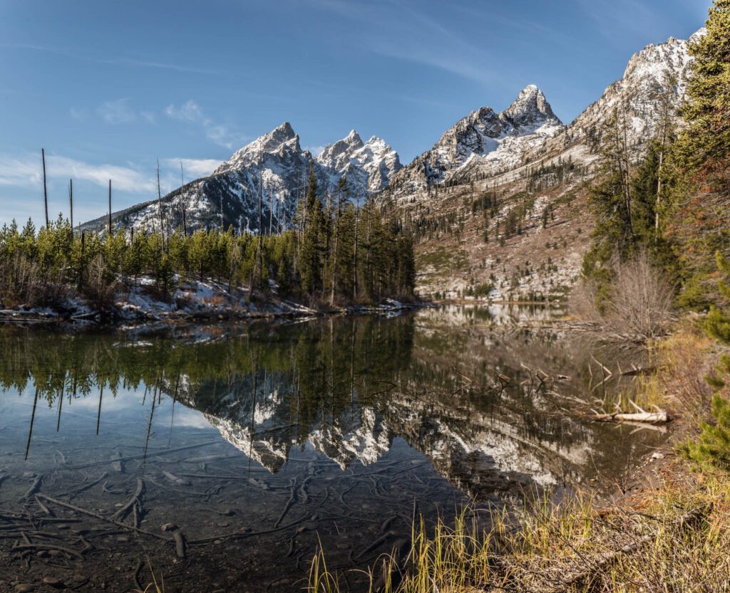
The Tetons are definitely the most dramatic mountain range I have seen, rising seemingly straight up 7,000 feet from flat western plains. The wildlife and plant species are equally grand—from huckleberries to moose, bears to lupines, lichen, wolves, sagebrush, marmots, aspen forests, trout, elk, yarrow, porcupines, and the list goes on…
When the rest of the American West can seem dry and arid, Grand Teton National Park is comparatively lush, with countless lakes, rivers, waterfalls, streams, and glacial melt filling every species with life. It really is a place deserving of the hype.

Tips for Hiking in Grand Teton National Park
Before we get into specific hikes, let’s quickly talk about the things you need to know before you embark on your Grand Teton adventure.
National Park Pass vs. Pay-per-Day
You will need to pay for entry into the park. An America the Beautiful Annual Pass (which gets you into any national park and also covers parking fees at most national monuments or national forest trailheads) is $80, and a single day pass into any national park, per vehicle, is $30.
The America the Beautiful Pass is worth the $80 if you’re planning on at least three National Parks in the next 12 months.
Parking and Crowds
Because Grand Teton National Park is one of the most visited national parks in the United States and there is limited parking, I always recommend that guests that want accessibility to any hikes on this list arrive early in the morning (9:00am at the latest), or, for short hikes, arrive later in the afternoon for the best parking chances.
Arriving at the park midday during peak summer months can mean a headache, waiting in lines for parking slots to open up.
The Laurance S. Rockefeller Center parking lot (parking for Phelps Lake) is especially small (50 car slots) and fills up quickly. Parking lines directed by park rangers are common at this center. Lupine Meadows Trailhead parking (for access to Delta, Surprise, and Amphitheater lakes) also fills up quickly.
Jenny Lake Ferry
The Jenny Lake Ferry is an amenity of the park that I recommend using for many of the Jenny Lake-centric hikes on this list.
Because so many trails begin on the western shore of the lake—three miles from the Visitor Center parking lot—the ferry is a great way to start or finish longer hikes to help shave off elevation and mileage.
The ferry is $10 one way / $18 round trip for adults, or $8 one way / $10 round trip for kids.
Elevation Acclimation and Altitude Sickness
There is quite an extreme elevation in the park (6,800 feet at the valley floor, and the Grand Teton is 13,776 feet tall), so many of the hikes on this list have significant elevation gain, and visitors should be wary of trying high-altitude strenuous hikes without acclimating to the elevation first. Symptoms of altitude sickness include nausea, headaches, and shortness of breath.
A general good rule is to take it easy and do some less strenuous hikes in the area before trying to ascend or summit anything. Any of the lake loops on this list would be perfect for the first days of your trip!
Sun Exposure
Because of the high elevation and sometimes sparse coverage while hiking up canyons, mountains, and over boulder fields, hikers are more prone to direct sunlight and more intense UV rays in Grand Teton National Park. Make sure to apply sunscreen throughout the day (Matt and Alysha here – we love Sun Bum!).
I also recommend bringing a good pair of polarized sunglasses. Sunglasses are especially helpful for any hikes that encounter snowfields, as snow acts as a reflector and can be blindingly bright. I have fair eyes and skin, and remembering sunscreen and sunglasses has improved my hiking experiences in the Tetons tenfold.
Unpredictable Weather
Hikers in Grand Teton National Park need to embrace that weather can be very unpredictable. As stated above, summer is the easiest season for hiking in the Tetons. Still, summer thunder and rain storms generally roll in quickly and unexpectedly, and preparing for them by bringing layers, packing wind and rain gear, and wearing appropriate shoes with traction can help you stay safe, dry, and warm.
Hydration
As with hiking anywhere, water is obviously important to bring along. Some of the hikes listed below are very long and strenuous, and water supply is a necessity for safety. Luckily, there are plenty of mountain streams, rivers, and glacial lakes along the way. I recommend packing a water purifying device for longer hikes like those to Lake Solitude and Cascade Canyon, or Delta, Surprise, and Amphitheater Lakes. An added plus of purifying water at those glacial lakes and rivers is having an ice-cold refreshing bottle for the exposed and dusty way down!
Wildlife Safety
Bear spray is a necessity in Grand Teton National Park, as it is in all national parks in the Rockies. You should have basic knowledge on how and when to use bear spray, and keep it within easy access on the side or front of your pack or belt. I have never had to use bear spray, but I have had a few close calls, and knowing my bear spray was easily accessible and that I knew how to employ it made me feel safe and capable while hiking in Grand Teton National Park.
If you are only planning on hiking a few days, consider renting bear spray. Rental shops in Jackson give good tutorials on how to use bear spray for first-time or beginner hikers — check out Teton Backcountry Rentals for bear spray rentals ($8/day for the first two days, then $4 a day for following days), crampon rentals, and other gear. You can’t take bear spray on planes, so renting is a cost-effective option for visitors traveling to the Tetons by air!
In addition, making noise or carrying a bear bell, especially while traveling through huckleberry patches, is a great way to alert nearby wildlife that you are passing through. Wildlife are a lot less likely to spook, charge, or maul if they are aware of nearby hikers.
That said, something to note is that bears are not the only dangerous animals in Grand Teton National Park. Please respect wildlife and do not approach moose, elk, or bison at all. A general rule is to not interact with any wildlife—including feeding critters like chipmunks.
Feel free to take pictures and observe (that’s half the experience in the park!) but do so from a very safe distance. Also, I’m sure this goes without saying, but if you come across a baby or wounded animal of any kind, do not touch it, try to care for it, or put it in your car.
Leave No Trace
Lastly, it’s always important while hiking in Grand Teton National Park, or in any other park, reserve, or outdoor space, to practice Leave No Trace principles. Conservation is a massive issue of philanthropy and federal protection in the Tetons, though folks sometimes forget that the smallest actions also add up and can affect local ecosystems. Especially with wildlife living on and around the same trail systems that hikers use, please make sure to pack in what you pack out.
The Best Hikes in Grand Teton National Park (From South to North)
Here are my top picks for day hikes in Grand Teton National Park, from the south end of the park to the north.
Phelps Lake
- Length: 7 miles
- Elevation Gain: 475 ft.
- Trail Type: Loop
- Difficulty: Moderate
- Trailhead Location
As a local, Phelps Lake is perhaps my favorite place in Grand Teton National Park to take visiting friends.
The trailhead begins at the Laurance S. Rockefeller Preserve Center, originally a dude ranch known as JY Ranch. The center is worth a visit before or after partaking in Phelps Lake Loop; visitors can learn about Rockefeller’s conservation philanthropy, historical ranch history, and sensory exhibits on plants and wildlife.
From the Preserve Center, the trail enters a forest and eventually (roughly a quarter mile from the parking lot) comes to a junction where hikers can choose either the Woodland Trail or Lake Creek Trail. The Woodland trail, which heads counter-clockwise around Phelps Lake, is the most direct trail to the lake loop, and is also the most scenic.
Similar to many of the lake loop trails on this list, Phelps Lake Loop has little elevation gain and mostly meanders along the shoreline after an initial mile and a half of forest and elevation gain. Moving counterclockwise on the loop, the hike provides constant and dramatic views of the Teton Mountain Range and Death Canyon.
Located on the northeastern shore of Phelps Lake is one of my favorite features of Grand Teton National Park: an iconic and popular jumping rock with super views of Death Canyon. The jump entails an exhilarating thirty-foot drop into cold mountain water. You won’t be able to miss the jumping rock, as there are always local teenagers and touring hikers stopping to sun-bath on it and jump off it into the deep glacial water below. Even if you don’t want to jump, it’s an entertaining stop on the trail. Eat a snack, hydrate, and watch jumpers throw backflips, spins, and dives into the lake.
If you do choose to partake in the jump, make sure someone snaps a photo of you midair. I’m afraid of heights and falling, so I only got peer-pressured into jumping off that rock once. I’m glad I did it that one time for the photo of me mid-air, Death Canyon also plummeting in the background.
Taggart Lake Loop
- Length: 3.8 miles
- Elevation Gain: 419 ft.
- Trail Type: Loop
- Difficulty: Easy
- Trailhead Location
Taggart Lake is the next lake and prominent hiking spot up from Phelps Lake. This trail doesn’t rely so much on shoreline hiking. Rather, the Taggart Lake Loop takes you on well-maintained pathways along Taggart Creek, over bridges with views of cascading waterfalls, by the National Park Service horse corrals, and through aspen groves. If you are visiting during the fall, this is a great loop to hike because of the lower elevation and fall aspens turning golden-yellow.
The trailhead is very well-marked for this one. Start from the Taggart Lake Trailhead, and about one-tenth of a mile into the hike, there will be a split in the trail that heads towards Beaver Creek. Continue to the right to keep on Taggart Lake Trail. If you are hiking in spring or early summer, I would recommend going counterclockwise around the loop. There are a few uphills on this hike that are quite significant, and the counterclockwise direction is a safer way if trails are slick.
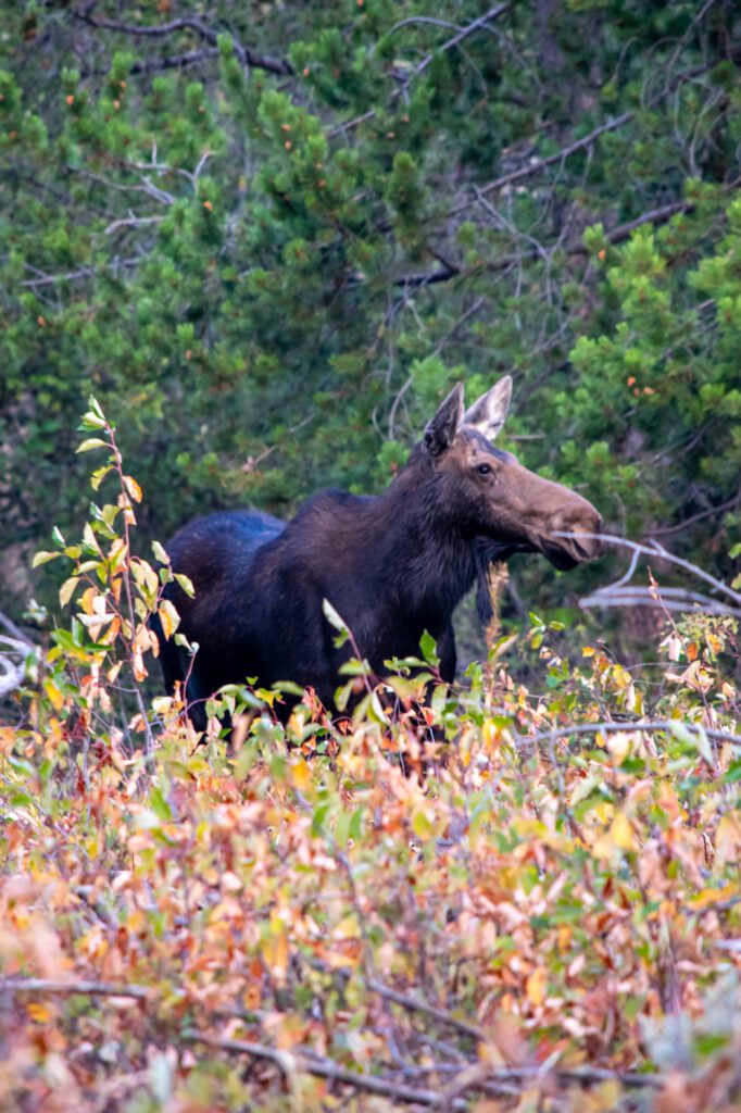
Once you arrive at Taggart Lake, there is great beach access. Also, as with any of the lake loops, Taggart Lake is a prime spot for wildlife sightings, especially moose. It’s a great area to take a break and soak in the sun and mountain views.
Branching off from Taggart Lake Trail, there is an optional trail to Bradley Lake. Hiking both lakes ups the mileage to 6 miles, with 761 feet of elevation gain.
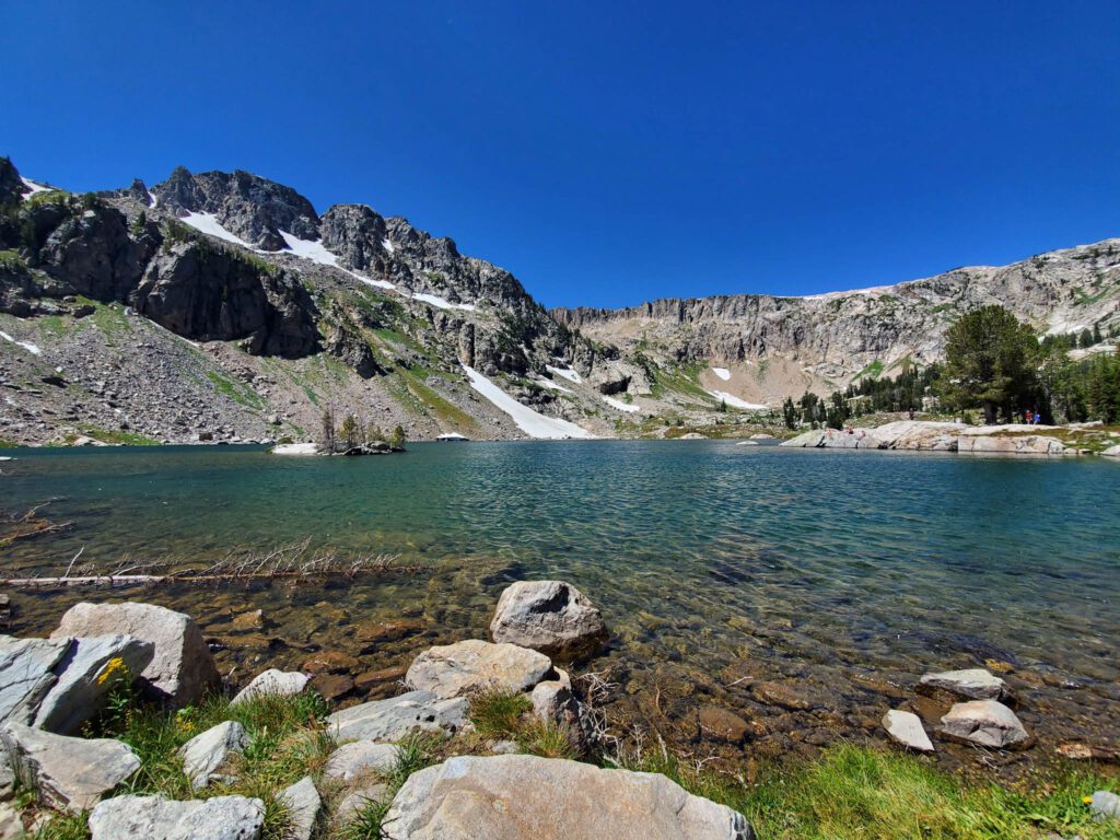
Surprise and Amphitheater Lakes
- Length: 10.2 miles
- Elevation Gain: 3,000 ft.
- Trail Type: Out and Back
- Difficulty: Hard
- Trailhead Location
The parking lot for Lupine Meadows Trailhead (the trailhead to use for Surprise, Amphitheater, and Delta Lakes) is unpaved, though larger than some of the paved parking lots in the park. Regardless, it fills up quickly. Overflow visitors usually park alongside the dirt road, though I’m not sure if that’s legal. Suffice to say, arriving here early is necessary for a few reasons: limited parking, the length of these trails, and the exposed terrain and altitude of these hikes.
Lupine Meadows Trailhead is flat for the first mile, meandering over a few boardwalk bridges, and has serene views of meadows, aspens, and pine. Quickly, however, the trail escalates and follows a ridge line. It gets really steep, really fast. The pro tip here is that hikers will get rewarding views of the valley floor and of Bradley and Taggart Lakes pretty immediately on this hike. Then, two miles in, the trail begins to switchback.
I actually love the switchbacks on this hike. They give hikers constant views of low-elevation lakes, the sprawling valley below, and throughout the summer the hillside is covered in wildflowers: mountain lupine, indian paintbrush, columbine, and so many more. And, though the switchbacks do add more mileage, they make this steep hike a lot more doable for the average hiker.
Regardless of the switchbacks, I recommend bringing hiking poles. Also, much of this hike is exposed with little tree coverage during the most difficult pitches. Make sure to bring adequate water, sunscreen, sunglasses, and a hat to keep the sun off your face and shoulders.
Unlike the trail to Delta Lake (which is unmarked and unmaintained), this trail is well-marked with signs pointing you to Surprise and Amphitheater Lakes the entire way up. After the switchbacks, you will follow signs to the lakes that bring you through high-elevation meadows, and eventually to the two glacial pools.
Surprise and Amphitheater Lakes are only a quarter mile apart, and both have rewarding views of the Grand Teton, Middle Teton, Disappointment Peak, Mt. Owen, and Teewinot. The historical location of early camps for mountaineering the Grand, these lakes are as close as you can get to these mountain peaks without actually summiting them. They are gorgeous glacial lakes, and so rewarding after the steep and strenuous ascent.
Delta Lake

- Length: 8.1 miles
- Elevation Gain: 2,316 ft.
- Trail Type: Out & Back
- Difficulty: Hard
- Trailhead Location
Also accessed at the Lupine Meadows trailhead, Delta Lake has become one of the most popular attractions in Grand Teton National Park, but only recently did it rise to the top of the list. It was a very well kept local’s secret until the progression of geo-tagging on Instagram and apps like AllTrails. To this day it isn’t a marked or maintained trail on park maps, though plenty of visitors know how to access it from online forums or word of mouth.
Hikers should take the Lupine Meadows Trail as if heading toward Surprise and Amphitheater Lakes (see guide above). When you get to the switchback portion of the trail, start keeping track. There will be six switchbacks before you reach the unmarked offshoot trail to Delta Lake.
On the sixth switchback, there will be a marked junction that gives you the option to go straight and continue towards Surprise and Amphitheater Lakes, or turn left towards Garnet Canyon. Go straight, still towards Surprise and Amphitheater. At the end of the sixth switchback, where the trail turns for a seventh, there will be a well-worn but unmarked trail that heads down into a pine forest (there are makeshift steps, though this trail is weathered). Turn onto that offshoot and follow the trail down into the pines.
There are plenty of technical obstacles on this last mile-long section: fallen pine trees to climb over or under, followed by a granite boulder field with rock cairns to point you in the right direction, and then a very steep and silty trail straight up a bare face. On the descent, I have scooted down parts on my butt—it’s that steep. I don’t recommend this hike to everyone purely for the last mile on that unmaintained offshoot.
But man, is it worth it once you get there. Delta Lake is truly unreal, a place close to heavenly paradise. Located just below the peak of the Grand Teton and nestled in by the Middle Teton, Owen, and Teewinot, it’s a smaller lake of milky turquoise glacial water, granite rocks, and drifting pine. I think it might be one of the most picturesque places on earth.

I’m not sure if I can recommend swimming in the lake— the glacial-water is at a constant near-freezing point—but brave souls do. It’s too shallow in most parts to jump or dive in (please don’t try, you really have no idea what you’re diving into with how milky-opaque the water is), but there are access points to poke feet in or wade out to.
Despite the immense popularity, there are still constant wildlife reports on and around this trail. I once came across an elk with velvety antlers standing right on the sixth switchback. The last time I hiked this trail, I spotted a grizzly bear scratching a tree only a half mile from the parking lot.
Jenny Lake Loop
- Length: 7.9 miles
- Elevation Gain: 623 ft.
- Trail Type: Loop
- Difficulty: Moderate
- Trailhead Location
Jenny Lake Loop is perhaps the most accessible and popular trail system in Grand Teton National Park, the reasons being that there isn’t much elevation gain, it is the second-largest lake in the park, and, despite being heavily trafficked, it’s serene and gorgeous the entire way. The trail mainly skirts the beaches of the lake and presents you with constant and rich views of the Teton Mountain Range.
After turning off the Teton Park Road at South Jenny Lake, you will park in the lot by the Jenny Lake Visitor Center. From there, the trail begins, and hikers can choose whether to hike clockwise or counterclockwise.
Either way, the trail is fairly heavily trafficked, though many hikers only hike halfway and return by ferry. In my experience, walking counterclockwise around the trail—headed towards String Lake—has fewer hikers.
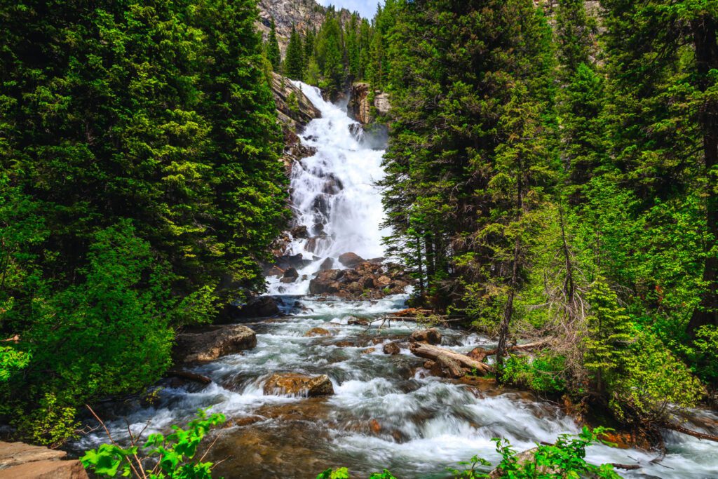
Inspiration Point and Hidden Falls
- Length: 1.8 miles (from Jenny Lake ferry dock)
- Elevation Gain: 410 ft.
- Trail Type: Out & Back
- Difficulty: Easy / Moderate
- Trailhead Location
Hidden Falls and Inspiration Point take you away from the shores of Jenny Lake and into the coniferous forests and huckleberry meadows of Grand Teton National Park.
From the boat dock, follow signs for Cascade Canyon Trailhead. You will first see signs to Hidden Falls a little less than a half mile up Cascade Canyon trail from the boat dock. It’s a short detour (0.1 miles) off the trail to the falls. Hidden Falls is very impressive and grand, plummeting glacial water one hundred feet down granite steps.
Returning to the trail and continuing on towards Inspiration Point, you will leave the coniferous forests and huckleberry meadows behind to scale up a steeper trail, returning to grand views of the Grand Teton, Mt. Owen and Teewinot. Inspiration Point is only an added mile from Hidden Falls, and well worth the ascent.
Because of its accessibility via ferry from Jenny Lake Visitor Center, this short-but-jam-packed hike is also heavily trafficked, perhaps the most heavily trafficked of any of the hikes on this list. However, the views of cathedral-like mountains, symphony of crashing water at the falls, and smell of coniferous pine in the air make this one of my favorite hikes in the park.
If you choose to skip the ferry, these attractions will be roughly six miles round trip from Jenny Lake Visitor’s Center (hiking counterclockwise around the lake), with approximately 600 feet of elevation gain.
Cascade Canyon

- Length: 9.1 miles (from Jenny Lake ferry dock)
- Elevation Gain: 1,102 ft.
- Trail Type: Out & Back
- Difficulty: Moderate / Hard
- Trailhead Location
Cascade Canyon Trail also begins at the west dock of Jenny Lake, accessed by ferry. The trailhead takes you up past Hidden Falls and Inspiration Point, and then on towards the Cathedral Group of Teton Mountains (the Grand Teton, Mt. Owen, and Teewinot).
Cascade Canyon is different from all the other canyons in Grand Teton National Park because it is quite a narrow canyon and a large, beautiful river flows down the entirety of it. You will be walking along that river for much of the hike. Because of constant water access and the length of this hiking trail, there is ample opportunity to spot wildlife, especially moose and bears. Matt and Alysha saw five moose while on this trail, and I have seen a few moose and one black bear as well!
About four miles in from Jenny Lake boat dock, the trail splits into North and South Cascade Trails. You can choose from there whether to keep hiking up the North Trail, which eventually leads to Lake Solitude, a gorgeous but isolated glacial lake (see guide below), or the South fork, which meanders along the back side of the Grand Teton. The South Trail is less travelled, but equally as beautiful and has views of more waterfalls along the way.
If you choose to skip the ferry ride, this hike will be 14.6 miles round trip from Jenny Lake Visitor’s Center, with approximately 1,300 feet of elevation gain.
Lake Solitude (via Cascade Canyon)
- Length: 14.2 miles (from Jenny Lake ferry dock)
- Elevation Gain: 2,500 ft.
- Trail Type: Out & Back
- Difficulty: Hard
- Trailhead Location
The above guide for Cascade Canyon gives you most of the hiking information for this hike. As a local and experienced hiker, I would definitely recommend starting this hike with the Jenny Lake ferry. If you choose to skip the ferry ride, this hike will be 20 miles round trip from Jenny Lake Visitor’s Center, with approximately 2,700 feet of elevation gain. Taking the ferry shaves off a few miles and gives you more time to relax in the high elevation meadows and wetlands you’ll encounter close to Lake Solitude.

However, this trail is more gradual in terms of hiking grade than other hikes on this list. If you are looking for a very long but moderate hike, or even a multi-day moderate backpacking trip, this would be a good canyon and lake to think about. Cascade Canyon is generally a great access trail to a grand network of backpacking routes in the upper Tetons.
Paintbrush-Cascade Loop, for instance, is a super rewarding multi-day backpacking trek in Grand Teton National Park that connects Cascade Canyon and Lake Solitude to String Lake through the Paintbrush Divide. The park service recommends checking in with a ranger at Jenny Lake Visitor Center to talk about conditions in Paintbrush Divide, as it holds snow until late July and can be dangerous without necessary equipment.
String Lake
- Length: 3.7 miles
- Elevation Gain: 291 ft.
- Trail Type: Loop
- Difficulty: Easy
- Trailhead Location
String Lake is a moderately-short, easy hiking loop that I would recommend to any level of hiker.
Moose love soaking in the shallow waters of this lake on their stilt-like legs, chomping on river and lake foliage. It’s no wonder this is the hike I have spotted the most moose on.
It’s also quite easy to find lake trout in the shallows of the water on this hike, especially with a good pair of polarized sunglasses. On most days, hikers can view not only moose and trout in the shallow shores of this lake, but a few fly fishers as well. The stream that connects String Lake to Jenny Lake is full of jumping trout, and is a popular fishing spot (for humans and bears) within the park.
Moreover, while many of the lakes on this list highlight the Grand Teton as the crown jewel of the mountain range, String Lake spotlights a very deserving Mt. Moran. You can also choose to add a mile to your trip and hike to Leigh Lake from String Lake trailhead; Leigh Lake has an even better view of Mt. Moran.
String Lake is one of the most peaceful and serene hikes in the park.
Getting to Grand Teton National Park
Grand Teton National Park is situated between Jackson Hole, Wyoming and Yellowstone National Park, with plenty of amenities bordering the park or located close by. It is a smaller park than Yellowstone or Glacier, which makes it fairly easy to travel to most of the sites in this guide in just a few days—although there are plenty of hikes and explorations in the park that could fill up a whole week or two (or my entire childhood). With that said, this list will hopefully give you some knowledge of the best hikes in the park, as well as what to expect while you’re there.
There are four entrance points to the park:
- Granite Canyon Entrance: The southernmost entrance point, best accessed if coming from Wilson, Wyoming, and located a few miles past Jackson Hole Mountain Resort.
- Moose Entrance: The most popular entrance, with quickest access to Jenny Lake if coming from Jackson Hole, Wyoming.
- Moran Junction Entrance: A northern entrance located closest to Jackson Lake.
- North Entrance: The entrance that links Yellowstone National Park to Grand Teton National Park via the Rockefeller Parkway.
For the purpose of efficiency, I will be listing the best hikes in the park from the south end of the park to the north, since Wilson and Jackson are the closest nearby towns and are situated south of the park. Also, there is an airport within the park, closest to the Moose entrance. It’s the only commercial airport in a national park, and flying in amongst the towering Tetons is definitely worth the airfare.
If you plan to enter from Yellowstone, you can reverse the list for your own ease and efficiency.

When to Go Hiking in Grand Teton National Park
Whatever season you choose to go hiking in Grand Teton National Park, there are always pros that vastly outweigh the cons.
Summer is the busiest season. Amongst the meadows and mountainsides full of wildflowers, there are also prolific huckleberry patches, near-constant wildlife sightings, lakes and rivers in full run-off flow, and temperate air. The hiking trails in Grand Teton National Park are best-maintained during summer months (June through August). However, if hiking through mud and snow doesn’t bother you, fall and spring are also wonderful times to hike, and see less crowds.
Fall is especially gorgeous in the Tetons, with aspen trees turning yellow and moose trudging through wetlands in search of final foliage to chomp on before the long winter. September and October generally see less visitors, so it’s easier to find parking spots and trails don’t feel congested. If you can pack and plan accordingly for the weather, fall is a wonderful time for hiking in Grand Teton National Park.
Winter can be a brutal time to visit the park with little to do in terms of hiking, but in my opinion, the Tetons look even more majestic with a full coat of fresh, white snow. With snow, the mountains appear twice as big. Though hiking may be out, you can drive and see bison and elk migrations, or rent cross country skis or snowshoes and trek on closed roads.
Spring, like fall, can be a great time to hike, conditions permitting. I would recommend sticking to lower-elevation lake loops during the spring season, as any elevation-gain trails may be slick with packed ice and mud from glacial melt.
There will still be plenty of snow on trails during the shoulder months of May and October. Usually, lower elevation trails like those around Jenny Lake and String Lake will be mostly clear of snow, but may still be muddy or slick.
Grand Teton National Park is open all year, though many roads are closed November through May due to winter conditions. For a list of which roads are open during the fall, winter, and spring, please see the GTNP roads report.
That’s all, folks!