Hiking in North Cascades National Park: A Complete Guide
Why do we love the North Cascades so much? It’s our kind of national park. And by that, we mean two things.
First, while some national parks (looking at you, Yellowstone) are all about the attractions that are just off the road, accessed by a short boardwalk (which means crowds galore), North Cascades National Park is all about the hiking.
The real magic starts to happen a couple of miles into a hike.
Second is the fact that, in the eternal struggle between mountain people and beach people, we couldn’t be further on the “mountain people” end of the spectrum.
The rugged rocky peaks of the North Cascades really do it for us.
We’re also addicted to alpine lakes, which you’ll see if you’ve read any of our other hiking guides.
The North Cascades also has that in droves.
The point is that if you’re into both hiking and mountains – and by extension hiking in the mountains – the North Cascades are essentially paradise.
We’ve been to North Cascades National Park many times at this point, with our most recent trip being this past fall to do some larch-spotting (which turned out to be a bummer because Matt sprained his ankle and was in a boot for that trip).
In this guide to our picks for best hikes in North Cascades National Park, here’s what we’re going to cover:
- A few important logistics to keep in mind as you’re planning, like the different passes you might need and seasonal considerations to know before you go.
- Our favorite hikes in the park – specifically the trails along Highway 20.
- A handy map of the trailheads for the hikes in this guide to help you visualize how it all fits together
Throughout the guide, we’ll share our favorite hikes, viewpoints, waterfalls, and more based on our trips to help you plan your North Cascades adventure.
Sound good to you? Let’s get into it.
Disclaimer: Some of the links in this post, like hotel links, are affiliate links, meaning at no additional cost to you, we make a little bit of money if you click through and book. That being said, we would never recommend something to you that we don’t stand behind 100%.
A Quick North Cascades Geography Overview
Before we get into this guide, we think it’s important to talk about the park’s geography.
While the area on the northern side of Mount Baker (along Highway 542 just south of the Canadian border) is TECHNICALLY the North Cascades, it is NOT part of North Cascades National Park.
I’ve seen some guides mentioning hikes along that stretch as part of the park, and it’s worth noting that it’s a full three hour drive to get from the visitor center out to the trailheads for those hikes.
For what it’s worth, we really love that part of Washington (read about it in our guide to hiking at Mount Baker), but it definitely doesn’t make sense to include any of those trails here.
For the purposes of this guide, we are talking about hikes that are along the Highway 20 corridor, which is the North Cascades Highway and goes all the way from I-5 over Washington Pass (and the Cascades) into eastern Washington.
Here’s a map of the park so you can see what we mean (Highway 20 is the red line).
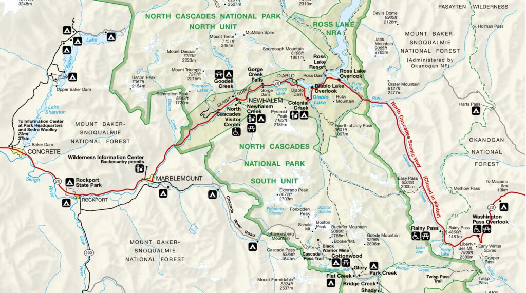
Every single hike in this guide is off of that thoroughfare, though it is worth noting that some trailheads require driving along potholed forest roads that can add a significant amount of drive time.
The other geography note is that most of our favorite hikes in the North Cascades, like Maple Pass and Blue Lake, are on the eastern side of the park near Washington Pass.
The implication here is mostly around where you choose to stay.
There really aren’t very many places to stay near the park, ESPECIALLY on the western side of the park and ESPECIALLY if you’re not up for camping.
If you’re camping, you want to either camp at Colonial Creek (the best campground inside the park), which is 35 minutes from the Maple Pass Trailhead, or outside the park at one of the forest service campgrounds on the eastern side of Washington Pass.
Lone Fir Campground and Klipchuck Campground are both good options, and they’re 20-25 minutes from those trailheads. Plus, they’re FAR less competitive than the campgrounds inside the park.
If it were us, we’d actually choose to stay outside the park on the eastern edge for the improved access to those trailheads.
If you’re not up for camping, staying outside the eastern boundary of the park is BY FAR the best option in terms of both quantity and quality of places to stay.
The charming town of Winthrop in the eastern foothills of the Cascades has the best combination of places to stay, amenities, and proximity to the park.
The Best Time to Visit North Cascades National Park
This section usually goes down near the end of a guide, but the answer here is different than most places – even within Washington.
It’s worth including it here at the top to help you avoid making the same mistake we made on our first trip, when we showed up in June expecting to be able to hike our hearts out only to find trails still covered in snow.
Hiking season in the North Cascades is incredibly short, lasting a couple of blissful months in the summer and early fall before the park falls dormant again.
There are two things to keep in mind when you’re planning your trip: weather and road closures.
Weather in the North Cascades is notoriously unpredictable, and can change in an instant.
However, it’s a pretty good bet that hiking trails, especially those at higher elevations, will be covered in snow through June and into July.
We know because we tried to go to the park in mid-June one year, and had to basically reschedule our trip despite already having flown to Seattle from the Bay Area. Whoops.
Basically, if you want to go hiking in the North Cascades, you need to plan your trip AFTER mid-July or so.
Peak hiking season is mid-July through the end of September, when the weather is warm, relatively dry, and the snow has melted from most, if not all, hiking trails.
For what it’s worth, we love September in the Pacific Northwest, and it’s our favorite time to hit the hiking trail in both Washington State and in our home state of Oregon.
You get the best parts of the summer – long days, warm weather, blue skies – with a few added bonuses like smaller crowds and more manageable sunrise/sunset times (5am sunsets are tough for photographers).
At some point in October, the famous larches of the Cascades start to turn a brilliant yellow color, and the ground starts to light up with hues of orange and red as fall color starts to come in all over the place.
It gets crazy busy in the Cascades as everyone and their entire family head out in search of the fleeting fall color, but it’s gorgeous and well worth braving the crowds for.
The tradeoff with hiking in October is cooler temperatures and more unpredictable weather (usually with a chance of rain).
As that fall color starts to fade, usually by the third week of October, the weather transitions to winter, when it’s cold, rainy, and sometimes even snowy.
Then the road closes (more on that in a second), and we’re back to waiting for next year’s summer season all over again.
A Note on Road Closures
Highway 20 (aka North Cascades Highway), the main thoroughfare through the park, closes between Ross Dam and milepost 171 on the other side of the Washington Pass Overlook in late November most years, and reopens sometime in the late spring (usually May).
That means you’ll be able to make it as far as Diablo Lake in the winter and early spring, but won’t be able to go much further than that.
Consequently, most of the hikes below are inaccessible between November and May, depending on the year.
Before you leave for the park, check current road conditions here.
Our 8 Favorite Hikes in North Cascades National Park
And now, let’s get into the hikes themselves!
Some of the best hikes in Washington State can be found in the North Cascades, and it’s an underrated hiking destination that is often overshadowed by the two more famous national parks in Washington, Olympic National Park and Mount Rainier National Park.
After going back and forth on the best way to organize this guide, we landed on ordering these hikes by our personal preference.
While there are plenty of details behind these recommendations in the more detailed guide below, here are our high-level recommendations on the “best” hikes in the park, which is of course entirely subjective (but this is our corner of the internet, and we rule it with an iron fist).
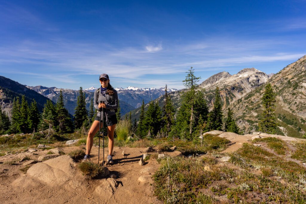
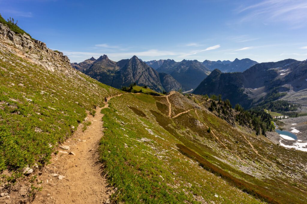
- If you’re up for a climb and want to get high into the subalpine meadows and rocky peaks that make the park special to us, we like the Heather-Maple Pass Loop, the Hidden Lake Lookout, and the Cascade Pass / Sahale Arm Trail.
- If you’re looking for something easier, the answer is the Blue Lake Trail, and we don’t think it’s particularly close.
Here’s the information you need to know to plan a hiking trip to North Cascades National Park.
Have another question? Don’t hesitate to get in touch, or leave us a comment below. We’re more than happy to chat!
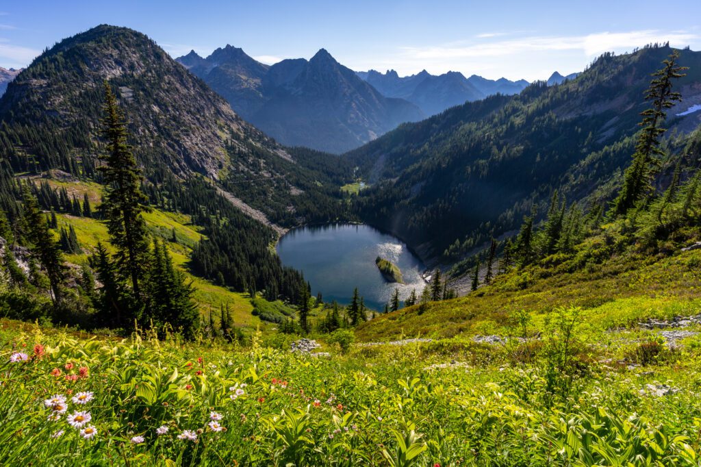
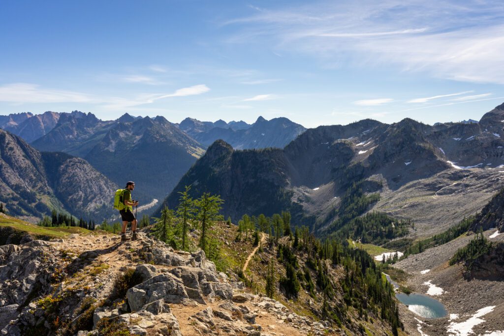
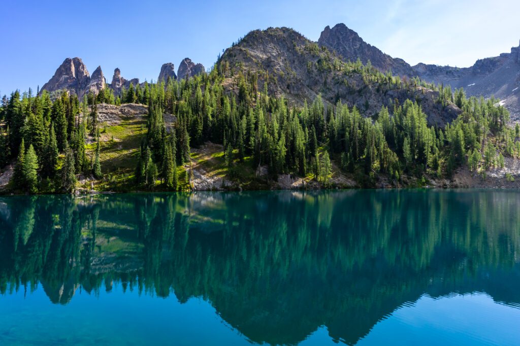
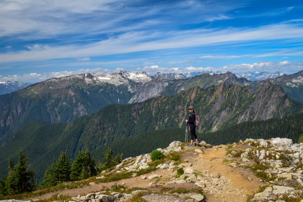
The Heather-Maple Pass Loop Trail
- Length: 7.2 miles
- Elevation Gain: 2,020 feet
- Trail Type: Loop
- Difficulty: Moderate / Hard
- Pass Required? Northwest Forest Pass OR America the Beautiful Pass
- Trailhead Location: Maple Pass Trailhead
In our humble opinion, the Heather-Maple Pass loop is the best hike in Washington State, at least in terms of bang-for-your-buck. It’s somewhere between a moderate and a difficult trail, but the views along the way are simply spectacular.
One of the coolest things about this hike is how the landscape changes over the course of the seasons.
In the summer, you have greenery and wildflowers blanketing the hillsides.
Come mid-October, that greenery turns a bright shade of orange or red, and the larches littering the landscape light up, bringing that signature pop of golden color to the rocky landscape.
The trailhead is easily accessible, located just off of Highway 20 at the eastern edge of the park, a few miles away from Washington Pass. The Pacific Crest Trail actually runs right through this parking lot.
The trailhead actually has plenty of parking, but it still manages to fill up on summer weekends.
Plan on arriving at the trailhead by 9am at the very latest to get a spot and hit the trail before the crowds arrive. Earlier is, of course, better.
The hike actually starts on US Forest Service land, not inside the national park, so you’ll need a Northwest Forest Pass to avoid getting a parking ticket.
We strongly, strongly recommend doing this hike counter-clockwise, which means a steadier climb and a steeper descent.
If you have bad knees, consider doing it the other direction, but know that the switchbacks climbing up that direction are absolutely brutal.
The hike starts with a steady uphill climb through the dense forest.
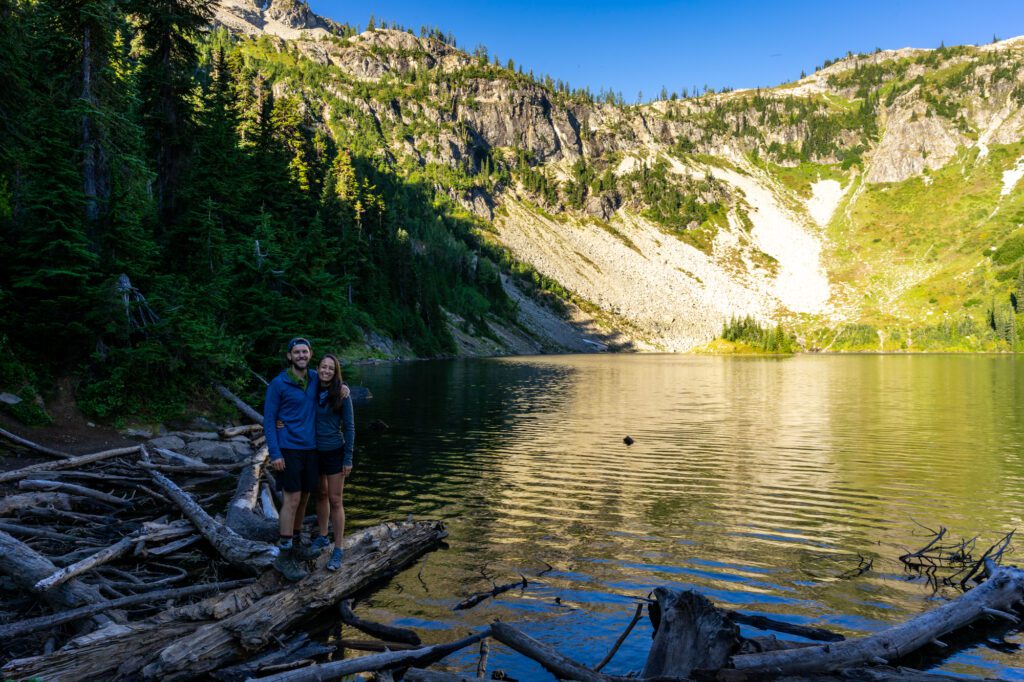
At 1.3 miles in, there’s an offshoot trail to the left that takes you to the shore of Lake Ann, and you should definitely do it.
Then continue along the trail, climbing above Lake Ann until you’re looking east, with Lake Ann in the foreground and the snowy peaks of the Cascades in the background.
Around this point is when you are inside the national park boundaries, although only briefly.
Take a breath and pause at the high point of the pass, which is four miles in and 2,000 feet higher than the trailhead, and take a break to grab a snack and some water before making the descent back down to the trailhead.
The descent is not a walk in the park. It’s steep, and trekking poles will be your friend as you lose 2,000 feet of elevation over the course of roughly two miles.
Read More: Hiking the Magical Heather-Maple Pass Trail in North Cascades National Park
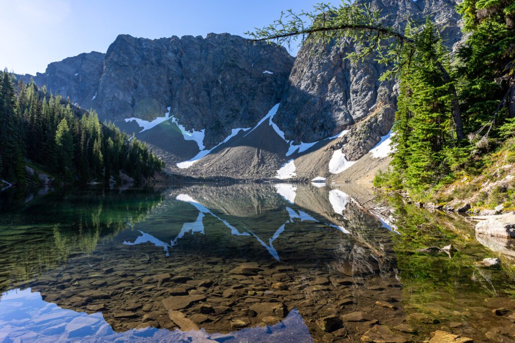
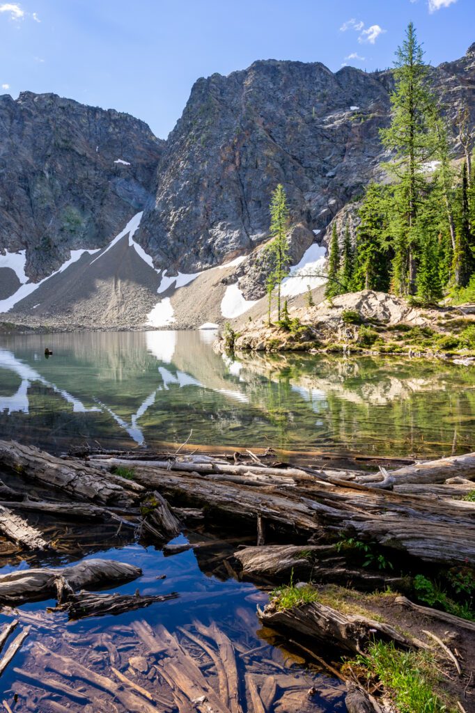
The Blue Lake Trail
- Length: 4.4 miles
- Elevation Gain: 1,050 feet
- Trail Type: Out and Back
- Difficulty: Moderate
- Pass Required? Northwest Forest Pass OR America the Beautiful Pass
- Trailhead Location: Blue Lake Trailhead
This hike is at the top of our list of the best easy hikes in Washington State because the reward-to-effort ratio is really, really high.
After a short, gradual climb through the forest (with occasional breaks in the trees to see the peaks that climbers are often ascending), you emerge onto the shore of a gorgeous alpine lake backed by those beautiful peaks.
If you’re looking for a moderate, family-friendly hike in the North Cascades, we think this hike is a great choice.
It’s on the easier side of moderate, climbing 900 feet over two and a half miles to reach that gorgeous alpine lake.
When the sun hits the lake, it shimmers and turns a bright blue-green color, which is pretty spectacular.
The trailhead for Blue Lake is near the Maple Pass trailhead, in Okanogan-Wenatchee National Forest.
There are only enough parking spots for maybe twenty cars in the parking lot, so make sure you get there early, or be prepared to either wait for a spot to open up or park on the side of Highway 20 (pay attention to the signage around no parking zones, though).
From the parking lot, you immediately enter the tree cover of the forest, with the sounds of cars zipping by on the road to accompany you for the first half mile or so.
The climb is pretty boring, to be honest. There’s one or two spots where you have views of the surrounding landscapes, but for the most part it’s a gradual climb through the forest.
Once you arrive at the lake, make sure to take some time to walk along both shores. There are some spectacular views to be had that are along the trails on both sides.
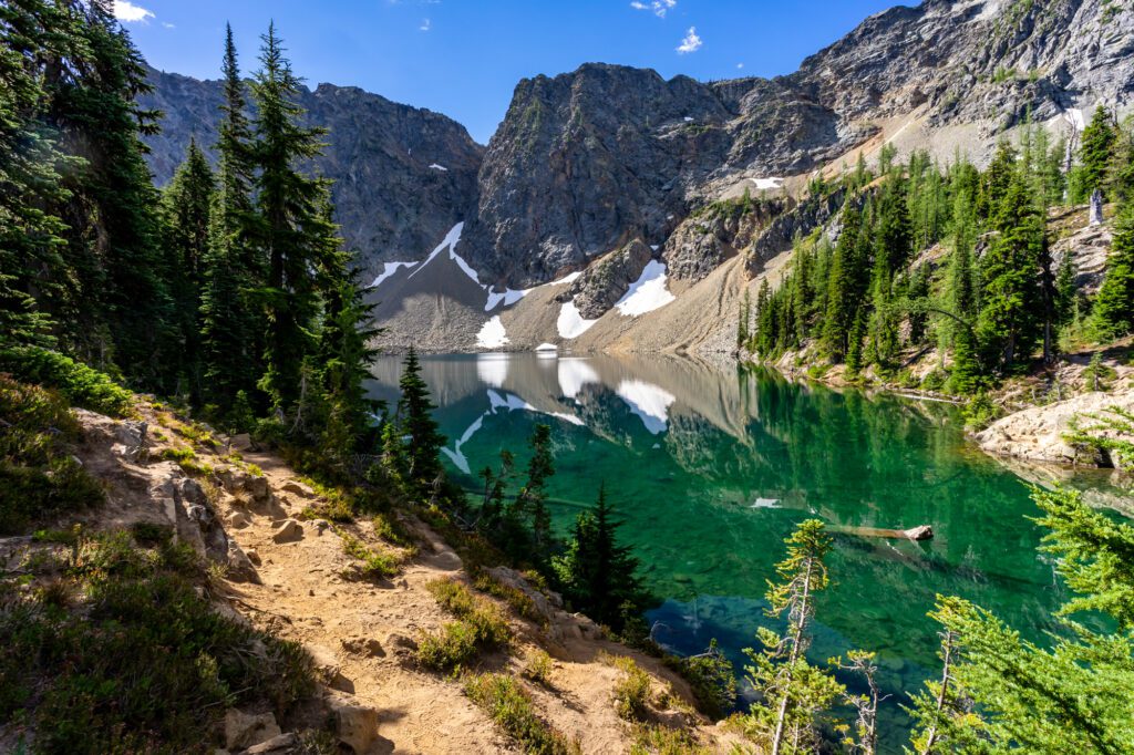
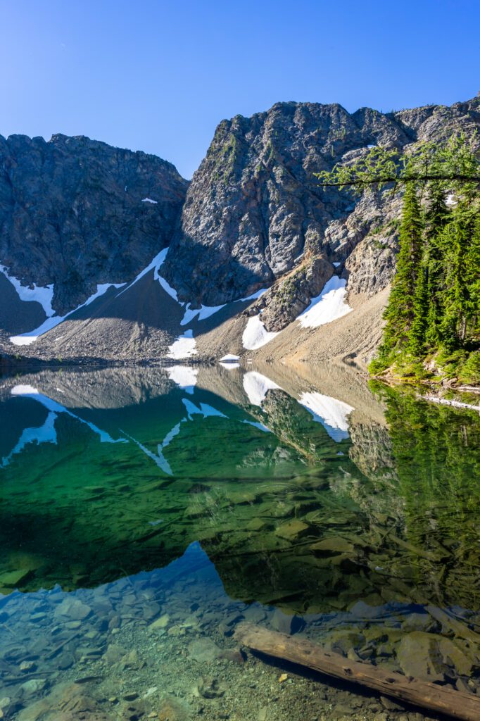
In particular, there’s a little loop on the right side of the lake with a nice tarn and some good views of the peaks of the North Cascades to the southwest.
It’s also a good place to see wildlife, including the elusive mountain goats that hang out on the scree on the far side of the lake.
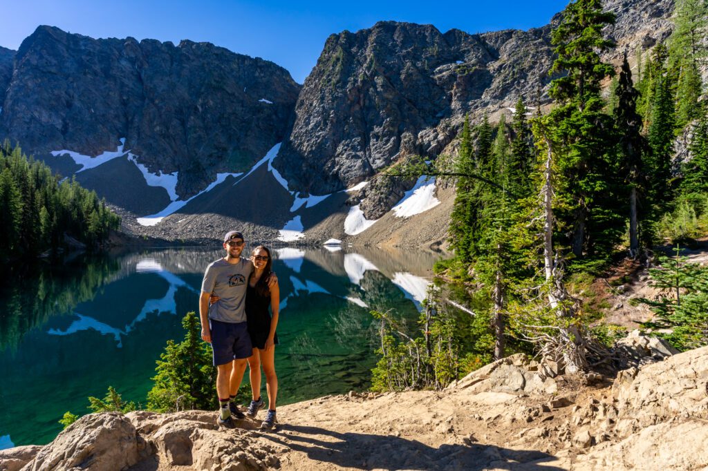
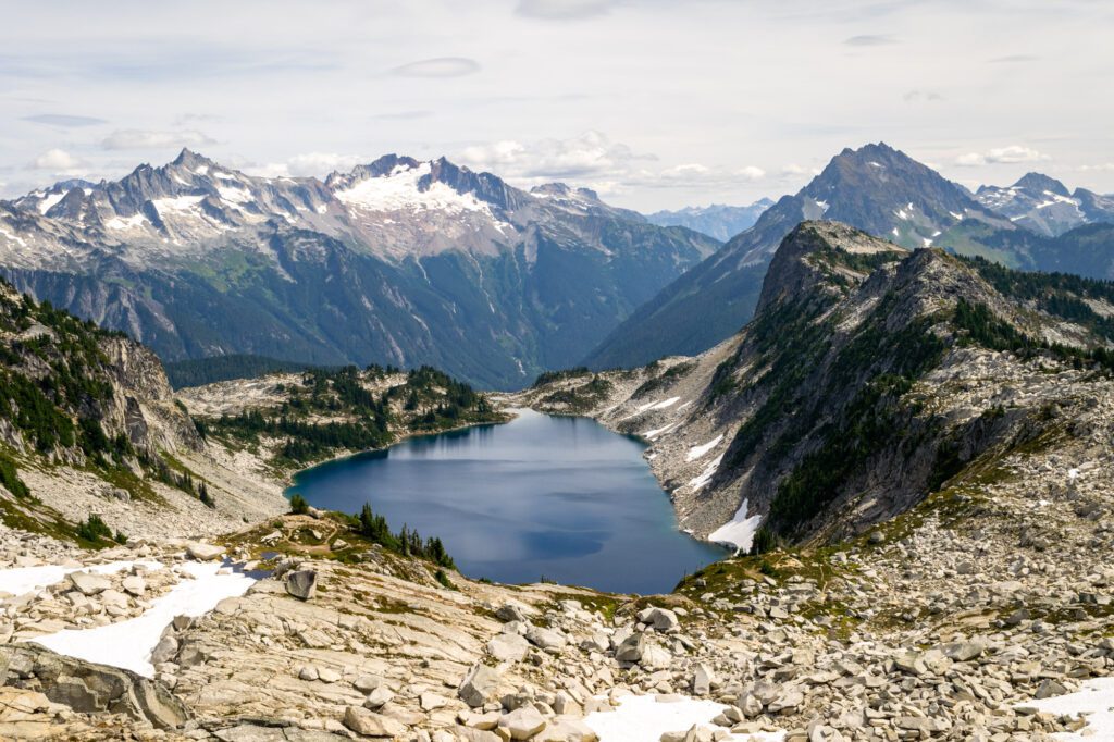
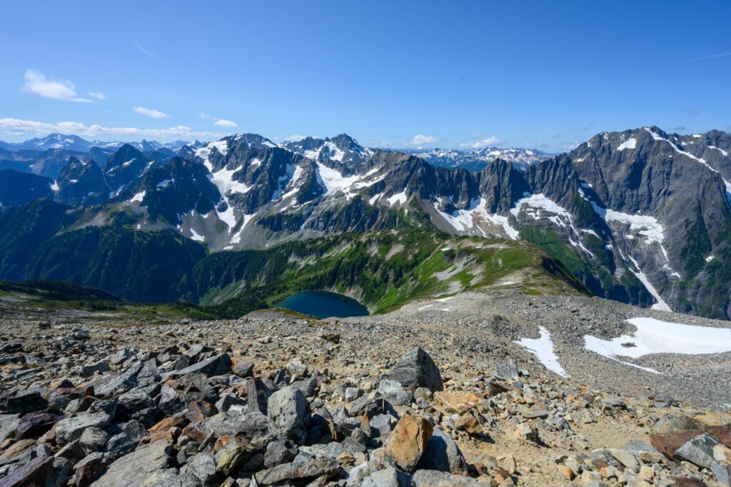
The Hidden Lake Lookout Trail
- Length: 8.0 miles
- Elevation Gain: 3,300 feet
- Trail Type: Out and Back
- Difficulty: Hard/Very Hard
- Pass Required? None
- Trailhead Location: Hidden Lake Lookout Trailhead
This was the first hike we ever tackled in the North Cascades, and it kind of set a crazy high bar for the rest of the hikes that followed.
This hike is spectacular, and is worth every hard-fought foot of elevation gain to get there.
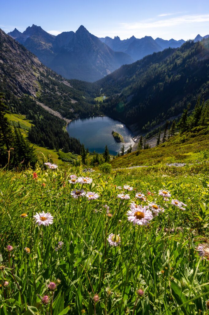
Let’s start with the payoff. At the end of this hike, there’s a perched lake waiting for you.
You’ll have the lake in the foreground, and the snowy peaks of the Cascades in the background, making for one of the most incredible views in the entire state.
Further up, you have the historic fire lookout – built in 1931 – that gives this hike its name. You can still stay overnight in the lookout, but it’s first-come, first-served and it’s VERY popular.
I’m not even sure how you would begin to go about getting a spot, but it definitely involves waking up at the crack of dawn on a weekday and a good deal of luck.
The trail starts at a small parking lot at the end of a dirt road that is a little bit bumpy and narrow.
Lucky for us, we had a SUV (thanks mom!), because I’m not sure our minivan would have made it.
That being said, there was a Prius in the parking lot, so if you have a regular passenger vehicle and you take it slow, you should be fine.
The trail takes you through three different landscapes as you make the climb to the lake.
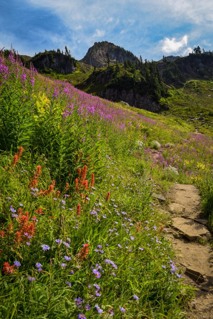
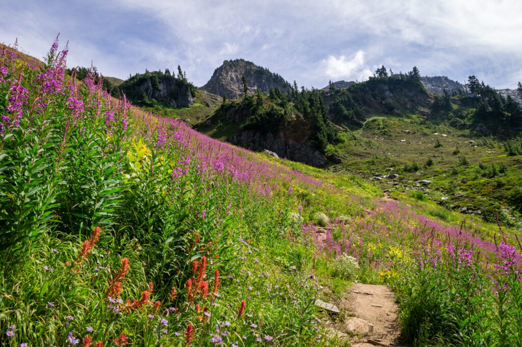
You’ll start in the forest for about a mile, then you’ll emerge into a meadow full of wildflowers, at least in the early summer (July), where you’ll climb a long series of switchbacks up the face of the mountain before the trail starts to turn rocky.
The last two sections, in particular, are beautiful. The climb through the open meadows is steep and difficult, but the wildflower displays in the early summer are magical.
At about 2.5 miles into the climb, two things happen. The trail makes a sharp right, and the landscape changes immediately from lush meadows to a rocky ridge. The views of the North Cascades from this ridge are stunning.
Eventually, you’ll climb over a ridge – which marks the boundary between the national forest and North Cascades National Park – and you’ll be rewarded with the picture-perfect view of Hidden Lake to the east. The lookout is a short climb up the ridge to your right.
The Cascade Pass / Sahale Arm Trail
- Length: 12.0 miles
- Elevation Gain: 4,000 feet
- Trail Type: Out and Back
- Difficulty: Very Hard
- Pass Required? None
- Trailhead Location: Cascade Pass Trailhead
Unfortunately, at the time of writing this guide, we actually haven’t personally done this hike because the 23 mile “loose gravel” road scared us and our Honda Odyssey off on our last trip to the North Cascades.
We figured it would take us over an hour each way to get to the trailhead, and spent our time elsewhere. Next time, we’ll bring a higher clearance vehicle.
The road is doable for regular vehicles, but you’ll have to take it slow and it will take a looooong time.
However, we’re including it in this guide because it is absolutely one of the best hikes in the North Cascades, and shouldn’t be missed if you’re venturing into the park and are looking for a hike that perfectly encapsulates what makes this part of the world special.
An important note up front: this hike is essentially two hikes in one: the initial climb to Cascade Pass, and the climb from Cascade Pass to the base of the Sahale Glacier.
The distance and elevation above reflect the entire climb from the trailhead to the Sahale Glacier.
If you just go up to Cascade Pass, the hike is a much more manageable 7.5 miles and 1,700 feet of elevation gain, and it’s still worth doing.
The trailhead is at the end of a 23 mile gravel road – called Cascade River Road.
The turnoff onto Cascade River Road is in the town of Marblemount, well before you reach the park’s visitor center in Newhalem (if you’re heading into the park from western Washington).
The trailhead has limited parking (get here early!) and bathrooms.
There are also several campgrounds along Cascade River Road on the way up, which would be a good place to spend the night before the hike to get an early start.
From the trailhead, the hike skips the warm up and gets right into a steep section of very tight switchbacks up a rocky hillside (where you’ll find our marmot friends squeaking at you!).
It’s a steady climb, and you’ll be shedding your layers almost immediately. That being said, the scenery is nice, especially when wildflowers envelop the trail in the early summer.
These switchbacks last for the first 2.5 miles (ish) of the hike, and represent the bulk of the climbing up to Cascade Pass.
You’ll start to get some nice views as you approach the top of the switchbacks, and things really start to get good when you arrive at the ridgeline and start the final push to the pass (which is about another mile).
Once you leave the pass heading towards the glacier, the trail gets both noticeably steeper and noticeably more beautiful.
It climbs through subalpine meadows that turn into a rocky ridge, ending with a steep rocky climb through a boulder field to Sahale Glacier Camp (and the end of this hike).
This is one of the higher elevation trails in the park, which means that you’re likely going to encounter snow along the top section that lingers in July and comes back sometime in September.
Be prepared with microspikes, plenty of layers (the temperature can vary wildly from the trailhead to the top of the ridge), sun protection, and plenty of food and water.
The Thunder Knob Trail
- Length: 3.6 miles
- Elevation Gain: 635 feet
- Trail Type: Out and Back
- Difficulty: Easy
- Pass Required? None
- Trailhead Location: Thunder Knob Trailhead
Looking for an easy hike in the park? In a park full of straight up, straight down thigh-burners, this is one of your best bets (especially on the western side of the park around Diablo Lake).
The trail leaves from across the road from the Colonial Creek Campground, which makes it a perfect trail for campers staying there (that’s how we did it) because you can walk to the trailhead.
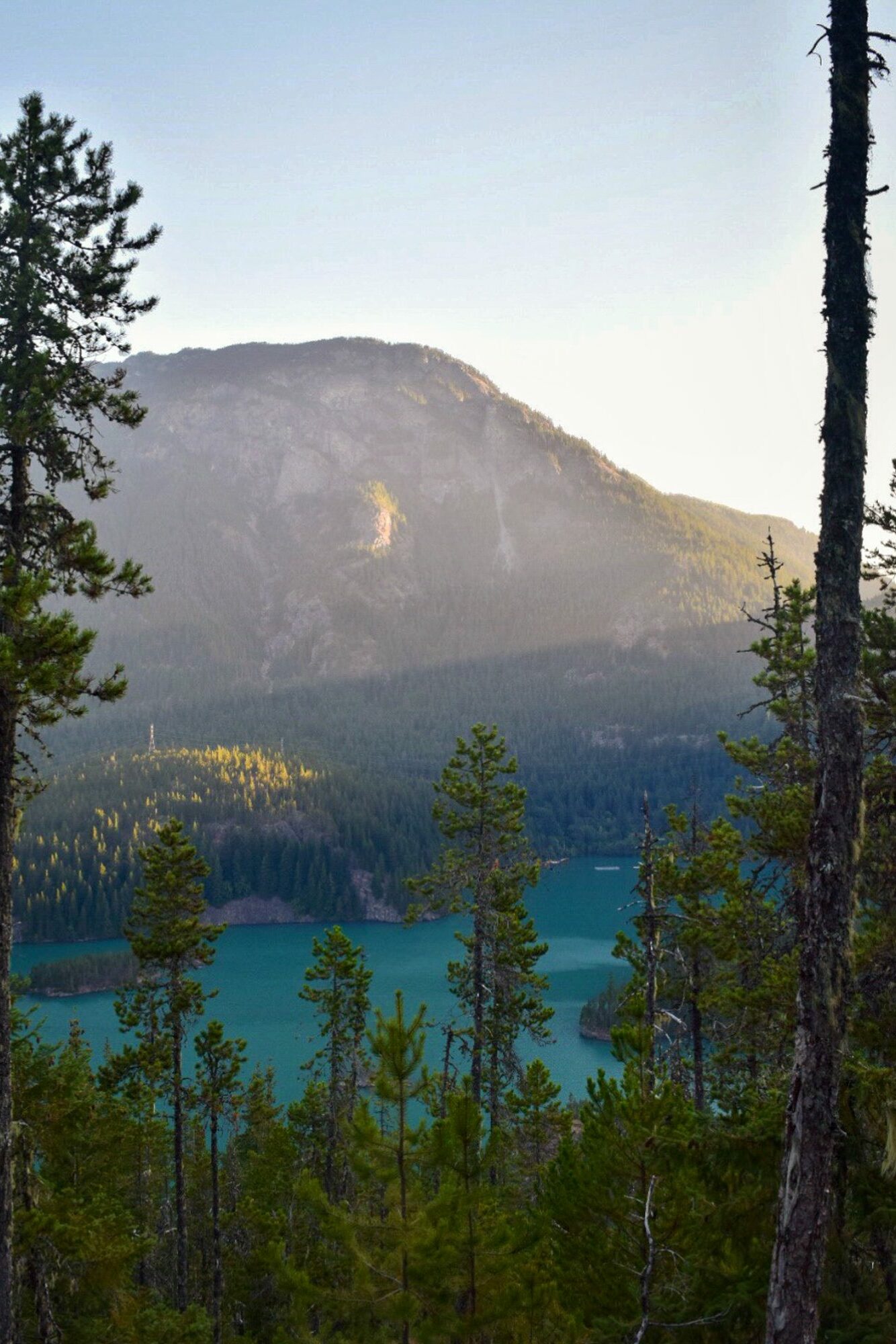
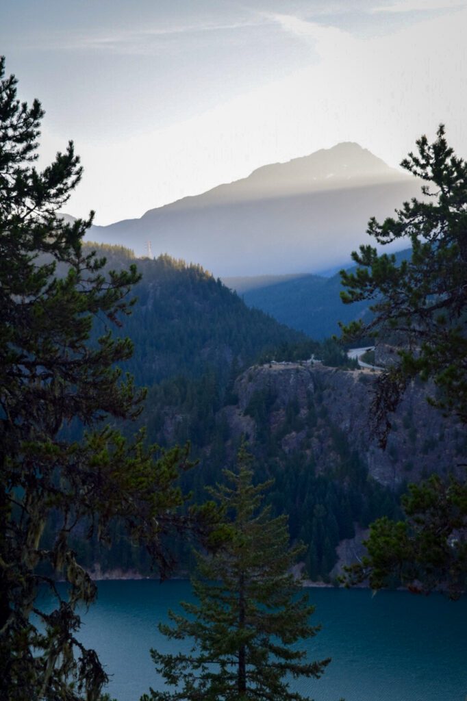
The trail itself climbs gently through the forest before arriving at a nice viewpoint, where you’ll be able to look over Diablo Lake from the west, which is the opposite direction you see it from the viewpoint off of Highway 20.
Take some time to explore the different viewpoints at the top. Several have benches, and are a good place for a snack before you return back to the campground (or your car).
The Sourdough Mountain Trail
- Length: 10.4 miles
- Elevation Gain: 4,870 feet
- Trail Type: Out and Back
- Difficulty: Very Hard
- Pass Required? None
- Trailhead Location: Sourdough Mountain Trailhead
Sourdough Mountain truly sits at the top of North Cascades royalty in terms of views out over the North Cascades.
The only issue is that the price of admission is, to put it lightly, VERY HIGH.
This hike is not easy. This hike is not moderate. This hike is not even difficult. This hike is VERY DIFFICULT.
The trail climbs almost 5,000 feet over the five miles to get up to the summit, which is fine for a mile or two over the course of a hike, but is absolutely brutal for a full five miles.
For reference, when we’re evaluating how difficult a hike is, anything over 500 feet of elevation gain per mile of climbing is in the “Hard” category. This is almost DOUBLE that.
If you’ve gotten this far into the description, chances are that you’re okay with the difficulty, so let’s talk about the hike.
The high point of this hike is the fire lookout that sits on the summit.
It was among the first lookouts established by the U.S. Forest Service, though the interior is closed to visitors now (if you want to go inside a fire lookout, Hidden Lake Lookout and Park Butte Lookout are good options).
To reach the trailhead, drive on Highway 20 past Marblemount for 20 miles until just before you reach the western edges of Diablo Lake. Turn left on Diablo Road, cross the Stetattle Creek bridge, keep right, and you’ll reach the trailhead in a quarter mile.
The trail to Sourdough Mountain gets down to business immediately.
The hike gets marginally less steep as it climbs, though you probably won’t even notice the difference because it’s a tough climb the entire way through.
You’ll gain 3,000 feet in the first two miles along seemingly endless switchbacks through dense forest. The forest eventually thins out, providing some views as motivation to keep pushing.
At about four miles, cross over Sourdough Creek – the first real water source on this hike – and pass Sourdough Camp, which brings you into slightly gentler terrain.
You’ll continue your ascent through expansive wildflower meadows and subalpine forest with a stunner of a vista dotted with glaciated peaks ahead.
Push up one final set of switchbacks to reach Sourdough Mountain.
The summit is sprawling grassy hills dotted with colorful flowers overlooking a series of peaks dusted with snow.
The turquoise waters of Diablo Lake snake between Pyramid and Colonial Peaks, painting an iconic and absolutely perfect Pacific Northwest scene.
Important note: This trail experienced a fire a few years ago, and is closed indefinitely.
It is unclear whether or not it will open for the upcoming summer and fall seasons (we’d guess not), but we will update this guide once we know more.
You can also get updates from the National Park Service.
Ladder Creek Falls
- Length: 0.5 miles
- Elevation Gain: 360 feet
- Trail Type: Out and Back
- Difficulty: Easy
- Pass Required? None
- Trailhead Location: Gorge Powerhouse
This hike leaves from the town of Newhalem, which is where the park’s main visitor center is located (you’ll pass right by it if you’re coming from the Seattle area), so it makes a nice combo stop on your way through to the rest of the park.
It’s more of a stroll than a hike, but it’s still worthy of a quick stop (especially if you’re looking to stretch your legs after a long drive).
The trailhead is located off of Highway 20 at milepost 120 at the eastern end of Newhalem.
You’ll need to park across the river from the Gorge Powerhouse. Cross the river on the suspension bridge to reach the path that leads you along this pleasant walk through nature.
This short but sweet foray into the forest brings you through Ladder Creek Gardens, blooming with wild flora, to close-up views of the cascading falls.
The path is paved and well maintained, with several benches along the way.
The mist rising from the falls is a perfect remedy for hot days. And if you happen to come at night, a 15-minute lightshow illuminating the gardens and falls runs from dusk until midnight throughout the year.
BONUS: The Park Butte Lookout Trail
- Length: 7.5 miles
- Elevation Gain: 2,200 feet
- Trail Type: Out and Back
- Difficulty: Moderate / Hard
- Pass Required? Northwest Forest Pass OR America the Beautiful Pass
- Trailhead Location: Park Butte Trailhead
First of all, this hike is actually near Baker Lake, outside the park boundaries on the western side, near the town of Concrete. But it’s worth a quick detour if you find yourself with some extra time.
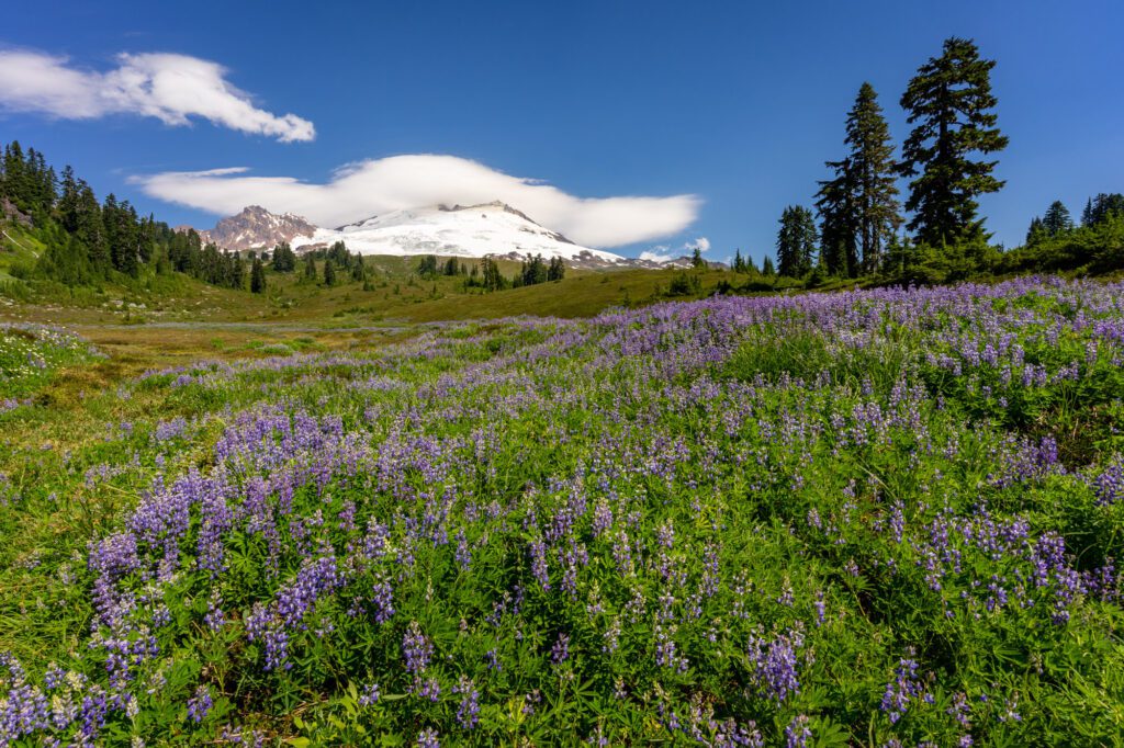
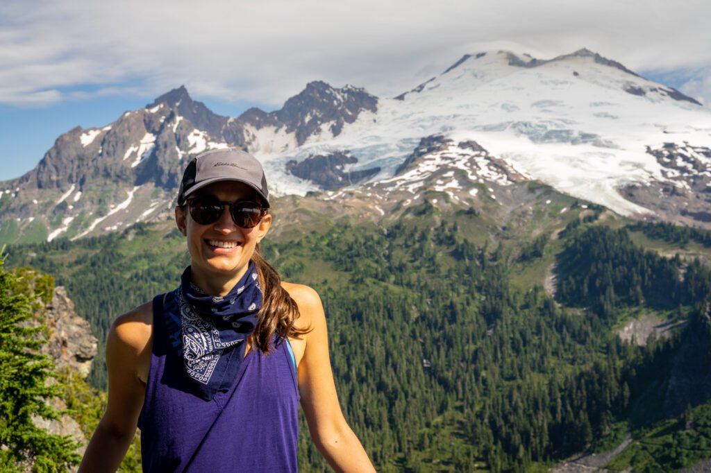
The payoff at the end of this hike is a spectacular view of Mount Baker’s southern face, with blankets of blooming wildflowers in the summertime.
You might be asking why this hike belongs in this guide, and not in a guide about hiking near Mount Baker.
It’s because this hike leaves from a trailhead on the south side of Mount Baker, which is about a three hour drive from Artist Point, which is the end of Highway 542 on the northern side of Baker.
It’s significantly closer to the other hikes in the park than it is to any of the other hikes in our Mount Baker guide, so it makes more sense to include it here.
The trailhead is at the end of a nine mile gravel and dirt road that is a little bumpy in places, but we did it in our minivan. Albeit, very slowly.
The trailhead itself is actually really nice, partially driven by the fact that this is where you start the climb to Mount Baker’s summit from the southern side.
From the trailhead, where there are multiple vault toilets, the trail itself climbs gently at first, crossing a creek and winding through the forest.
Then you hit a series of switchbacks that climb aggressively for about a mile before you’re dumped into a wide open meadow, which is where the views of Mount Baker begin to materialize.
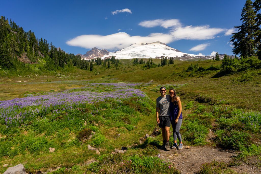
You’ll climb through a meadow, blanketed with lupine and other wildflowers during the summer, before the terrain turns rocky.
The views of Baker are nothing short of spectacular basically the entire way through.
The end point of the hike is a fire lookout that looks north at Mount Baker.
Spend some time up there, and find a good spot for a snack before descending back the way you came.
This is another fire lookout that you can spend the night in, though it is also very popular and will require an early wake up call, a healthy dose of luck, and the ability to turn around and head back down if there’s no space left by the time you arrive.
The Best Hikes in the North Cascades, Mapped
Pro-tip: To view a full size version of the map, click on the “expand” icon in the top right.
Backpacking in the North Cascades
Above, we’ve covered the day hikes in the park, but what if you want to do an overnight trip?
You’ll need a backcountry permit, and there are three ways to get one.
Note that the split between reserve-in-advance permits and walk up permits is roughly 60% / 40%, as it has been for the past few years, but a lottery has been put in place to make things more equitable and run a bit smoother.
The Early-Access Lottery: Similar to other high traffic areas in the state like the Enchantments, the North Cascades have implemented a lottery for a portion of backpacking permits.
Applications for summer and fall permits are accepted between March 2-13, winners (and losers) are notified on March 20, and then lottery winners can make early-access reservations from March 24 – April 21. More info here.
The General On-Sale Period: The other portion of reserve in advance permits are dumped into the online portal after the lottery reservation period is over. This is going to be April 29 at 7am PST.
This is when everyone who didn’t enter or didn’t win the lottery can make reservations.
Walk-up Permits: The other 40% of permits are first-come-first-served, held at the Wilderness Information Center in Marblemount.
You’ll have to head there either the day of your trip, or the day before to see if they have availability.
Go early, and be prepared to be flexible in terms of timing and what trail you choose. More info here.
There are several locations where you can pick up a backcountry permit, including the Wilderness Information Center in Marblemount and North Cascades Park Headquarters in Sedro-Woolley.
It’s also worth noting that your permit must be picked up by 11am on the first day of your trip, otherwise your reservation will be canceled.
Note: All overnight permits for routes off of Cascade River Road, which includes the Cascade Pass Trail / Sahale Arm Trail, are issued exclusively at the Marblemount Wilderness Information Center.
Things to Know Before You Visit the North Cascades
Here are a few things that we think you should know before you visit North Cascades National Park.
The hiking season is tragically short. We touched on this above, but it bears repeating.
Don’t make the same mistake we did and show up in early July thinking everything will be snow-free and ready to tackle without winter hiking equipment.
The best time to hit the trail with little fear of snow and ice is late July through the end of September.
There are very few places to stay near the park. There are, essentially, zero places to stay on the west side of the park between Marblemount and the I-5 corridor OTHER THAN CAMPING.
If you’re camping, stay at either Colonial Creek or Newhalem Creek Campground.
If you’re not camping, the charming town of Winthrop in the eastern foothills of the Cascades has the best combination of places to stay, amenities, and proximity to the park.
It’s worth stopping at the Visitor Center to check on trail conditions and closures.
The visitor center is located off of Highway 20, near the town of Newhalem and Newhalem Creek Campground as you’re entering the park from the west (the direction of Seattle).
Stop by the center between 9am and 5pm between May 18th-September 30th, where you’ll find maps of the park and surrounding area, multimedia exhibits on the natural and cultural history of North Cascades National Park, and short, interpretive trails.
Note that you can’t pick up backcountry permits here, that is done at the separate Wilderness Information Center which is in Marblemount (here on Google Maps).
This national park does NOT require a pass to enter, but you might need a parking permit at certain trailheads. The good news is that there aren’t any national park fees for North Cascades National Park!
However, you will need a Northwest Forest Pass to park at many of the trailheads.
Backcountry hiking requires a backcountry permit, which you have to pick up in person. You will need to reserve your permits online in advance on Recreation.gov.
All backcountry permits to camp overnight in the park must be picked up in person at the Wilderness Information Center in Marblemount.
More information on the process for applying for and acquiring backcountry permits here.
Leave the dogs at home. No dogs allowed on any hikes in the North Cascades, as the trails are all in a national park (except for a portion of Maple Pass, which passes into national forest land).
This rule helps preserve the trails and the flora and fauna in national parks.
More to Explore in Washington State
Heading to the great state of Washington? Here are some other posts you might like.
- The Best Things to Do in Seattle: A Complete Guide for First Timers
- Where to Stay in Seattle: 5 Amazing Areas to Stay
- How to Plan an Amazing Weekend in Seattle (3 Day Itinerary)
- Two Days in Seattle: The Best of Seattle in 48 Hours
- One Day in Seattle: How to See The Best of Seattle in a Day
- The 8 Best Day Trips from Seattle: A Complete Guide
- 10 Amazing Weekend Getaways from Seattle: A Complete Planning Guide
- Where to Find the Best Coffee in Seattle: 15+ Amazing Seattle Coffee Shops
- Gluten Free Seattle: A Complete Travel Guide for Celiacs
- How to Plan an Amazing Washington State Road Trip
- The 19 Best Airbnbs in Washington State
- 33 Incredible Cabins in Washington State
- 12 Amazing Easy Hikes in Washington State for Beginners
- How to Plan an Amazing Olympic National Park Itinerary
- What to Do in Leavenworth, Washington: A Complete Guide
- What to Do on San Juan Island: A Complete Visitors Guide
- The Best Things to Do on Orcas Island: Complete Planning Guide
- The Best Things to Do on Vashon Island: A Complete Day Trip Guide
Hi Matt, thanks for this guide. We are travelling from the UK to hike in this area for three weeks in about a month from now. This guide looks super helpful. It’s a pity Sourdough looks like it is still closed but you never know, fingers crossed it reopens. We will be sure to tick these hikes off we go.
Hey Will! We’re going to be up in that area too in August – we’ll see you on the trail! You’re going to love it – it’s one of our favorite places in the world. Sourdough Ridge is likely going to be closed for years after the fire last year. Cheers!