The Comet Falls Trail: Our Favorite Waterfall at Mt. Rainier
On our latest trip to Mount Rainier National Park, it was our goal to make it to the big four waterfalls in the Paradise area – Narada, Christine, Myrtle, and Comet Falls.
By the evening of our last full day, we had checked off the first three, and we were planning on getting up at the crack of dawn to hike the Comet Falls trail before heading back home.
Having seen the other three waterfalls over the course of a couple of days, we weren’t quite sure what to expect when it came to Comet Falls.
Each of the other three falls has something special going for it – Myrtle has the backdrop of Rainier’s glaciated peak, and Christine has a fun framing with the stone bridge – and we were wondering what that “something special” would be for Comet Falls.
As we rounded the bend in the trail and got our first glimpse of Comet Falls through the trees, the answer quickly became clear.
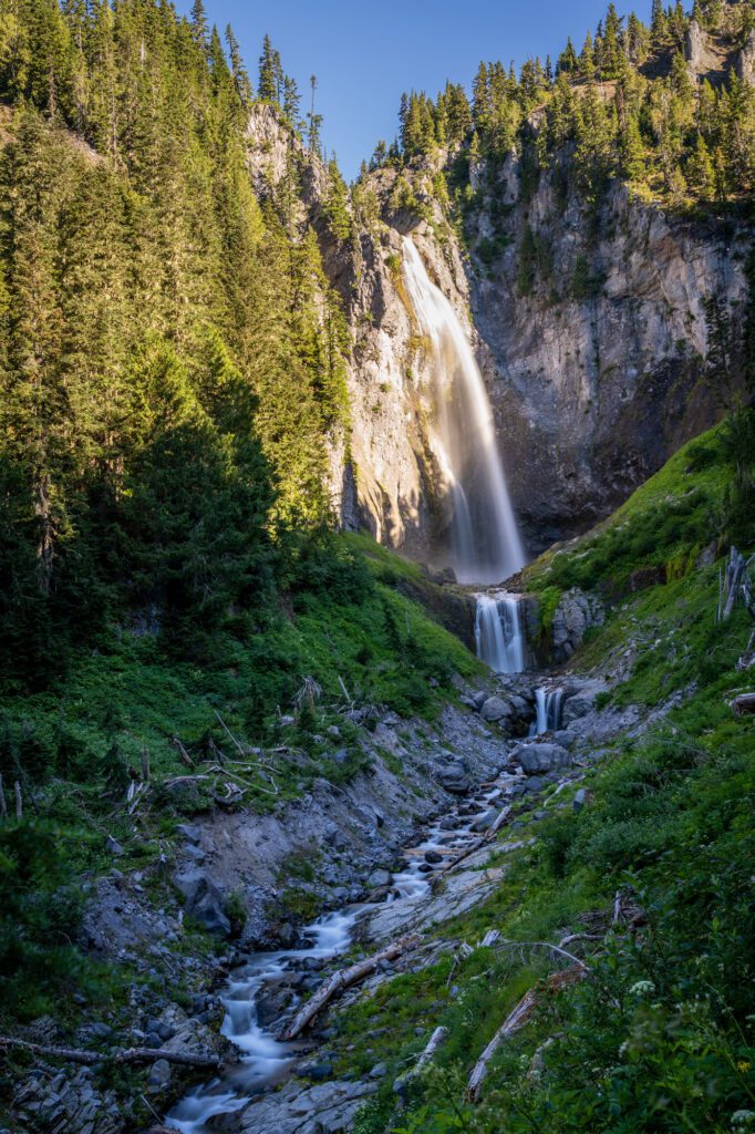
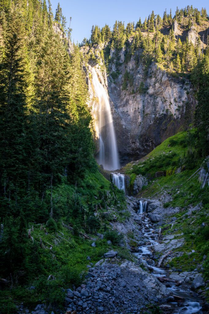
It’s the sheer scale.
Comet Falls is 300 feet tall, and is equally impressive from far away with its winding river and cascading smaller falls in the foreground, as it is up close.
It dwarfs the other waterfalls in the area and is well worth the extra effort to get to compared to those other waterfalls, which are largely accessible from the parking lot (or within a quarter mile of it).
In this guide, we’re going to give you all the details you need to be prepared to hike the Comet Falls Trail, which has jumped onto the list of our favorite hikes in Mount Rainier National Park.
We’ll go through parking, what route to take, and a play-by-play trail guide that is all based on our own personal experience.
Our goal is to give you a complete picture of what to expect before you hit the trail.
Sound good to you? Let’s get into it!
Disclaimer: Some of the links in this post, like hotel links, are affiliate links, meaning at no additional cost to you, we make a little bit of money if you click through and book. That being said, we would never recommend something to you that we don’t stand behind 100%.
Hiking to Comet Falls: Trail Details
- Length: 3.8 miles
- Elevation Gain: 1,250 feet
- Season: Mid-July – September/October
- Trail Type: Out and Back
- Difficulty: Easy / Moderate
- Trailhead Location
- Dog Friendly: No – NO DOGS ALLOWED
- Pass Required: America the Beautiful Interagency Pass or $30 entrance fee
The Route
There’s really only one way up to Comet Falls, although there are a couple of extensions you can do to add distance to your hike and get truly off the beaten path, which is kind of a hard thing to accomplish in a place as popular as Mount Rainier National Park.
The main route follows the Comet Falls Trail from the trailhead up past Christine and Bloucher Falls before arriving at Comet Falls.
Going Further to Van Trump Park or Mildred Point
If you want to get a little further away from the crowds and take in some less-visited views, there are two great add-ons to the Comet Falls Trail to consider.
Unfortunately, we tackled this on our last morning in the park, and had to skip both since we had to get back home by the afternoon.
However, Van Trump Park in particular is on our list for our next foray into Paradise!
The easier – but by no means “easy” – add on is to hike up to Van Trump Park, a meadow that sits at about 6,500 feet above sea level with great wildflowers in early August (ish – it depends on the year) with views of Rainier looming in the distance.
The climb from Comet Falls up to Van Trump Park is only an extra mile one-way (two miles round trip), but that mile is BRUTAL.
You’ll need to climb 1,000 feet over the course of that mile to get up into the alpine meadows of Van Trump Park. Make sure you have plenty of food, water, and sun protection.
The second addition – Mildred Point – is a longer journey with a similar elevation gain to reach a rocky outcropping with excellent views of the Mountain.
You’ll add four miles and about 1,400 feet of elevation gain to the main trail to get up to Mildred Point.
Getting to the Trailhead + Parking
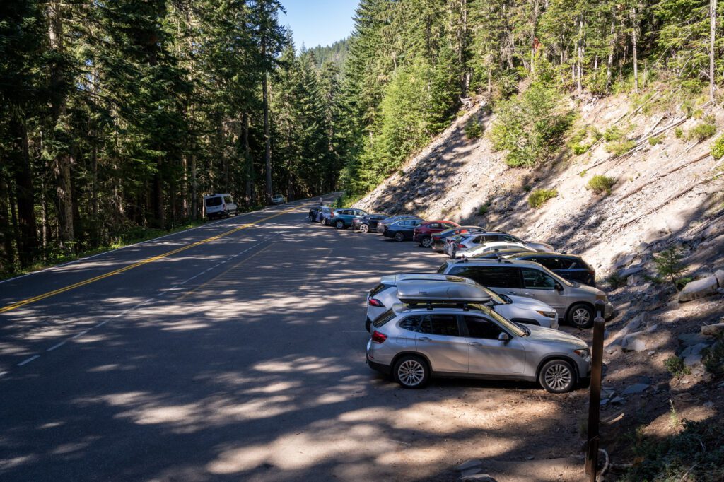
The Comet Falls Trailhead is on the northern side of Paradise Road E (on your left if you’re coming up from the park entrance).
If you’re coming from the Nisqually Entrance, just follow the road about 10 miles up from the park entrance, and you’ll see the small parking lot on your left.
If you’re coming down from the direction of Paradise, drive 7 miles downhill from the Henry M. Jackson Visitor Center and you’ll see the trailhead on your right after passing Christine Falls.
It’s just past the big bridge on the way down from Ricksecker Point.
There are no bathroom facilities at the trailhead!
If you’re coming from the direction of the Nisqually Entrance station, stop at the restrooms at the Cougar Rock Picnic Area (here on Google Maps).
If you’re coming from Paradise, go before you leave, or stop at Narada Falls (here on Google Maps) where there are restrooms across the stone bridge.
The Comet Falls Trail: A Mini Trail Guide
Normally, we have these guides broken up into distinct trail sections, covering the distance and elevation gain of each and giving a mini trail report on each section with our observations, tips, and thoughts.
However, we’re only covering 1.9 miles of trail or so in this guide (since it’s an out and back hike), so we’re going to do it all in one big section.
This trail report is based on our own personal experience hiking the Comet Falls Trail in August in the early morning.
Normally, we break this section up into smaller, more digestible chunks, but given that the trail is just under four miles long, we’re going to do it all in one big section.
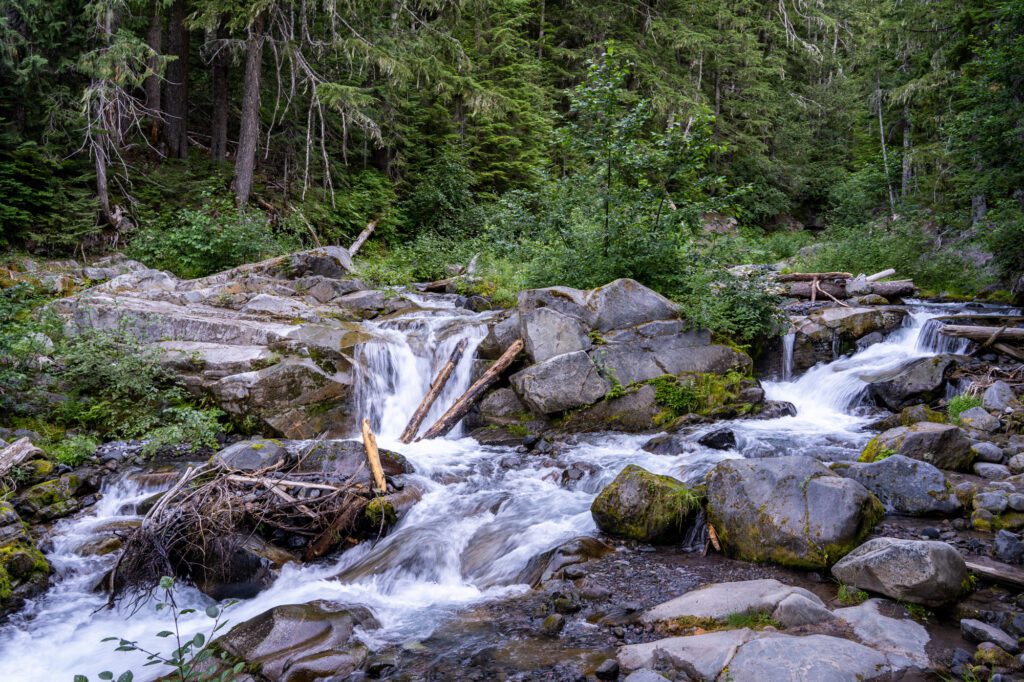
From the trailhead, you’ll start climbing immediately. You’ll enter the forest, and a quarter of a mile later, you’ll reach a sturdy wooden footbridge that crosses over Van Trump Creek just above Christine Falls.
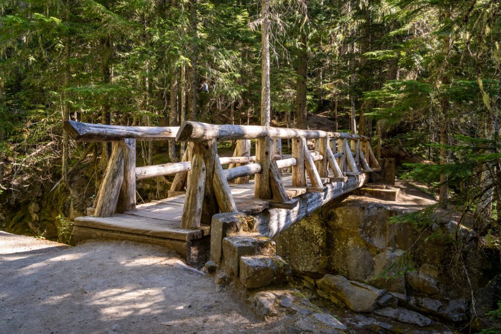
You’ll see the top of the falls from above, but the far, far better view is just up the road at the Christine Falls pullout.
There is, however, a nice view of a cascade of Van Trump Creek on the north side of the bridge.
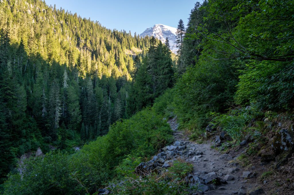
From there, the trail continues following Van Trump Creek up the canyon. High walls show the work that the water has done over the millenia – at points, the canyon is so deep that you can barely see the water, despite the sound of the water being ever-present as you hike.
We love hikes that follow a river, and provide that white noise as you’re trudging uphill.
At 0.6 miles in, you’ll hit your first set of switchbacks, climbing 300 feet over the next 0.2 miles. Like we said, this hike is harder than we expected.
At the top of those switchbacks, you’ll notice the landscape starts to change.
Two things jumped out to us.
First, the canyon is wider, and the sound of the river is less… aggressive?
Second, as you’re walking, you’ll start to notice that your feet are now landing on rocks rather than the hard-packed dirt in the forest.
On your right as you climb, you’ll pass a couple of rocky slopes that are prime pika territory. If you’ve never seen a pika before, they’re like a cross between a bunny and a hamster, and they LOVE the rocks on this trail.
The first time we saw one on this particular hike, it was dragging a huge fern across the trail, and Matt didn’t see the pika and was very, very confused.
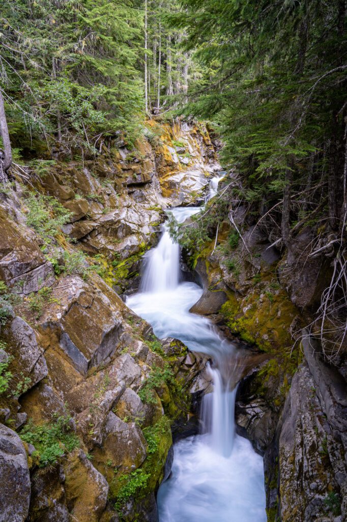
Finally, you’ll emerge from the forest at the base of a waterfall! But… wait? You might be thinking “this isn’t Comet Falls. Or at least it looks different from pictures I’ve seen of it.”
Correct! This is Bloucher Falls, and this is the BONUS waterfall we mentioned above. We had no idea this was here, and it was a very pleasant surprise.
If the hike was just up to this waterfall, we wouldn’t have been terribly disappointed.
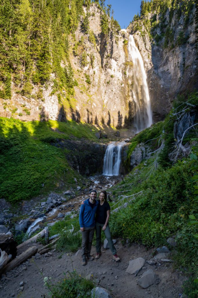
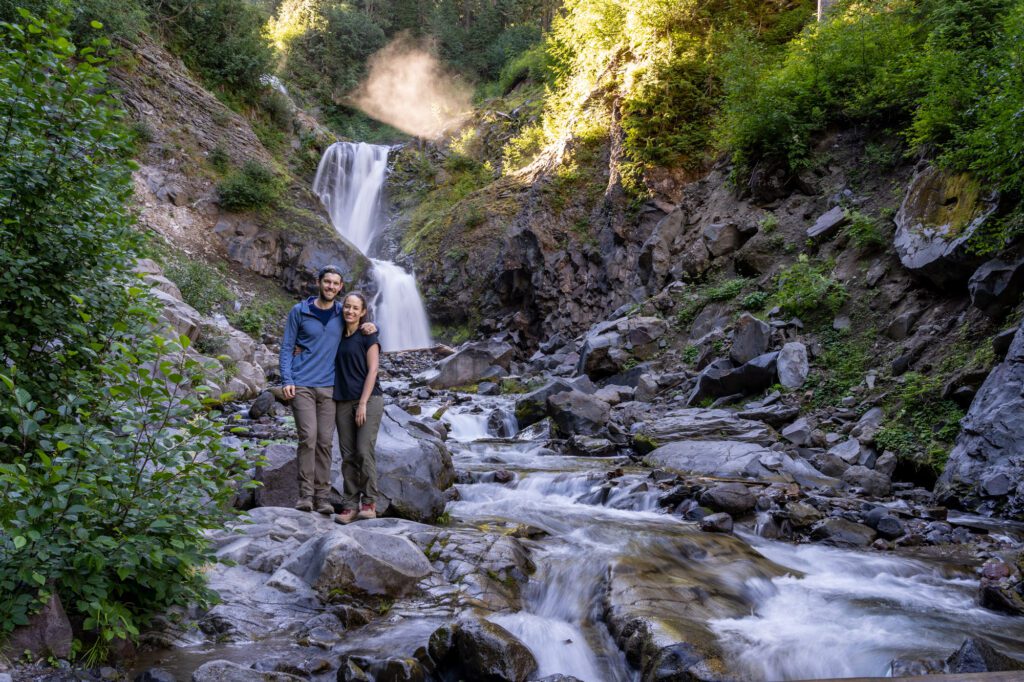
But if you continue another 200 feet around the bend, the 300 foot drop of Comet Falls awaits.
There are a few great viewpoints here – we liked the first view of the falls you get from the trail, which includes the long, snaking creek below the falls.
You can also follow the trail on your right, which takes you to a closer view.
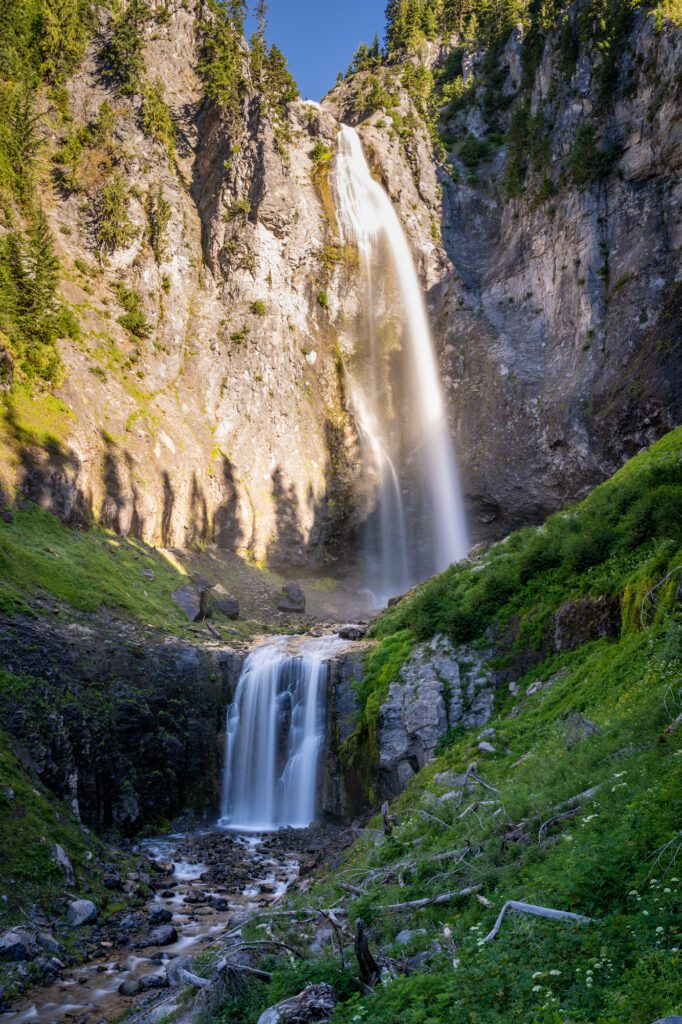
The last option is to do some extra climbing to crest the hill on the right hand side of the falls, which gets you to the base of the falls.
You’ll come to a trail junction here – right continues up to Van Trump Park and Mildred Point, left goes to the falls. Careful on the wet rocks, they’re slippery!
Planning a Trip to Mount Rainier National Park? You won’t want to miss our detailed guides to visiting Mount Rainier that are all based on our own personal experience exploring the park.
- All of Our Favorite Things to Do in Mount Rainier National Park
- How to Plan an Unforgettable Day Trip to Mount Rainier From Seattle
- Where to Stay near Mount Rainier National Park: A Complete Guide
- The Best Hikes in Mount Rainier National Park: A Helpful Hiking Guide
- Hiking the Skyline Trail: Is This the Best Hike in the Entire State?
- Hiking the Jaw-Dropping Burroughs Mountain Trail at Mount Rainier
- Hiking to Towering Comet Falls in Mount Rainier National Park
- The Naches Peak Loop: The Best Bang-for-your-Buck in Washington